
Carte topographique Ua Pou
Carte interactive
Cliquez sur la carte pour afficher l’altitude.
À propos de cette carte
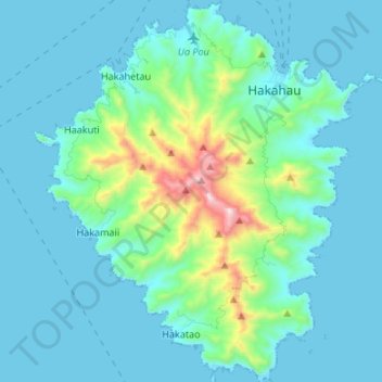
Nom : Carte topographique Ua Pou, altitude, relief.
Lieu : Ua Pou, Marquesas Islands, French Polynesia, France (-9.46723 -140.13578 -9.33490 -140.01976)
Altitude moyenne : 127 m
Altitude minimum : -4 m
Altitude maximum : 919 m
It is located about 50 km (30 mi.) south of Nuku Hiva, in the northern Marquesas. The center of the island is characterized by four high basalt pillars that reach high above the surrounding mountains. The highest of these pillars, Mount Oave (Mont Oave), reaches to 1,230 m (4,040 ft) above sea level and is the highest elevation in the Marquesas.