
Carte topographique Loop
Carte interactive
Cliquez sur la carte pour afficher l’altitude.
À propos de cette carte
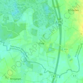
Nom : Carte topographique Loop, altitude, relief.
Altitude moyenne : 29 m
Altitude minimum : 22 m
Altitude maximum : 41 m
Autres cartes topographiques
Cliquez sur une carte pour visualiser sa topographie, son altitude et son relief.
Fleckeby
Germany > Schleswig-Holstein > Rendsburg-Eckernförde
Fleckeby, Schlei-Ostsee, Rendsburg-Eckernförde, Schleswig-Holstein, 24357, Germany
Altitude moyenne : 17 m
Borgstedt
Germany > Schleswig-Holstein > Rendsburg-Eckernförde
Borgstedt, Hüttener Berge, Rendsburg-Eckernförde, Schleswig-Holstein, 24794, Germany
Altitude moyenne : 14 m
Warder
Germany > Schleswig-Holstein > Rendsburg-Eckernförde
Warder, Amt Nortorfer Land, Rendsburg-Eckernförde, Schleswig-Holstein, 24646, Germany
Altitude moyenne : 28 m