
Carte topographique Vandiperiyar
Cliquez sur la carte pour afficher l’altitude.
Vandiperiyar
It is located at an altitude of 836 m above MSL.
À propos de cette carte
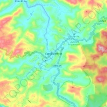
Nom : Carte topographique Vandiperiyar, altitude, relief.
Lieu : Vandiperiyar, Peerumade, Idukki, Kerala, 685533, India (9.53292 77.05189 9.61292 77.13189)
Altitude moyenne : 919 m
Altitude minimum : 782 m
Altitude maximum : 1 191 m
Autres cartes topographiques
Cliquez sur une carte pour visualiser sa topographie, son altitude et son relief.
Periyar National Park Tiger Reserve
Periyar National Park lies in the middle of a mountainous area of the Cardamom Hills. In the north : The boundary commences from the point nearest to the Medaganam in the interstate boundary up to Vellimalai. and the east Thence the boundary follows the inter-state boundary from Vellimalai to Kallimalai Peak…
Altitude moyenne : 929 m