
Carte topographique Knutsford
Carte interactive
Cliquez sur la carte pour afficher l’altitude.
À propos de cette carte
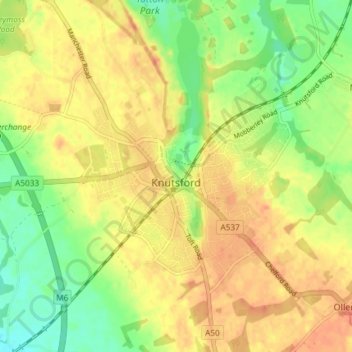
Nom : Carte topographique Knutsford, altitude, relief.
Lieu : Knutsford, Cheshire East, England, United Kingdom (53.28683 -2.39841 53.31990 -2.33256)
Altitude moyenne : 58 m
Altitude minimum : 36 m
Altitude maximum : 75 m
Autres cartes topographiques
Cliquez sur une carte pour visualiser sa topographie, son altitude et son relief.
Nether Alderley
United Kingdom > England > Cheshire East
Nether Alderley, Cheshire East, England, United Kingdom
Altitude moyenne : 98 m
Smallwood
United Kingdom > England > Cheshire East
Smallwood, Cheshire East, England, United Kingdom
Altitude moyenne : 86 m
Wilmslow
United Kingdom > England > Cheshire East
Wilmslow, Cheshire East, England, United Kingdom
Altitude moyenne : 81 m
Norbury
United Kingdom > England > Cheshire East
Norbury, Cheshire East, England, United Kingdom
Altitude moyenne : 82 m
Bickerton Hill
United Kingdom > England > Cheshire East > Bickerton
Bickerton Hill, Bickerton, Cheshire East, England, CH3 9LE, United Kingdom
Altitude moyenne : 134 m
Wilmslow
United Kingdom > England > Cheshire East
Wilmslow, Cheshire East, England, SK9 1DS, United Kingdom
Altitude moyenne : 84 m
Alderley Edge
United Kingdom > England > Cheshire East > Alderley Edge
Alderley Edge, Cheshire East, North West England, England, United Kingdom
Altitude moyenne : 91 m
Middlewich
United Kingdom > England > Cheshire East
Middlewich, Cheshire East, England, United Kingdom
Altitude moyenne : 40 m
Ashley
United Kingdom > England > Cheshire East
Ashley, Cheshire East, England, WA15 0QR, United Kingdom
Altitude moyenne : 44 m
Cholmondeston
United Kingdom > England > Cheshire East
Cholmondeston, Cheshire East, England, United Kingdom
Altitude moyenne : 48 m
Nantwich
United Kingdom > England > Cheshire East
Nantwich, Cheshire East, England, United Kingdom
Altitude moyenne : 45 m
Church Minshull
United Kingdom > England > Cheshire East
Church Minshull, Cheshire East, England, United Kingdom
Altitude moyenne : 45 m
Smith's Green
United Kingdom > England > Cheshire East > Barthomley > Smith's Green
Smith's Green, Barthomley, Cheshire East, North West England, England, CW2 5NU, United Kingdom
Altitude moyenne : 80 m
Disley
United Kingdom > England > Cheshire East
Disley, Cheshire East, North West England, England, United Kingdom
Altitude moyenne : 229 m
Chorley
United Kingdom > England > Cheshire East > Chorley
Chorley, Cheshire East, North West England, England, United Kingdom
Altitude moyenne : 73 m
Walgherton
United Kingdom > England > Cheshire East > Wybunbury > Walgherton
Walgherton, Wybunbury, Cheshire East, North West England, England, United Kingdom
Altitude moyenne : 63 m
Macclesfield
United Kingdom > England > Cheshire East
Macclesfield, Cheshire East, England, United Kingdom
Altitude moyenne : 182 m
Congleton
United Kingdom > England > Cheshire East
Congleton, Cheshire East, England, United Kingdom
Altitude moyenne : 119 m
Crewe
United Kingdom > England > Cheshire East
Crewe, Cheshire East, England, United Kingdom
Altitude moyenne : 52 m
Doddington
United Kingdom > England > Cheshire East
Doddington, Cheshire East, England, United Kingdom
Altitude moyenne : 73 m