
Carte topographique Chattogram
Carte interactive
Cliquez sur la carte pour afficher l’altitude.
À propos de cette carte
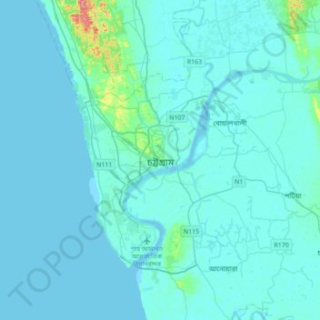
Nom : Carte topographique Chattogram, altitude, relief.
Altitude moyenne : 6 m
Altitude minimum : -2 m
Altitude maximum : 101 m
Chittagong lies at 22°20′06″N 91°49′57″E / 22.33500°N 91.83250°E / 22.33500; 91.83250. It straddles the coastal foothills of the Chittagong Hill Tracts in southeastern Bangladesh. The Karnaphuli River runs along the southern banks of the city, including its central business district. The river enters the Bay of Bengal in an estuary located 12 kilometres (7.5 mi) west of downtown Chittagong. Mount Sitakunda is the highest peak in Chittagong District, with an elevation of 351 metres (1,152 ft). Within the city itself, the highest peak is Batali Hill at 85.3 metres (280 ft). Chittagong has many lakes that were created under the Mughal rule. In 1924, an engineering team of the Assam Bengal Railway established the Foy's Lake.
Autres cartes topographiques
Cliquez sur une carte pour visualiser sa topographie, son altitude et son relief.
Moulovi Para
Bangladesh > Chattogram Division
Moulovi Para, Cox's Bazar District, Chattogram Division, 4760, Bangladesh
Altitude moyenne : 4 m
Cox's Bazar
Bangladesh > Chattogram Division > Cox's Bazar
Cox's Bazar, Cox's Bazar District, Chattogram Division, 4700, Bangladesh
Altitude moyenne : 13 m
অক্সিজেন
Bangladesh > Chattogram Division > অক্সিজেন
অক্সিজেন, Chattogram District, Chattogram Division, 4223, Bangladesh
Altitude moyenne : 15 m
Khuruskul
Bangladesh > Chattogram Division > Khuruskul
Khuruskul, Cox's Bazar District, Chattogram Division, ৪৭০০, Bangladesh
Altitude moyenne : 5 m
Kaptai Lake
Bangladesh > Chattogram Division
Kaptai Lake, Rangamati Hill District, Chattogram Division, Bangladesh
Altitude moyenne : 102 m