
Carte topographique Igoji
Carte interactive
Cliquez sur la carte pour afficher l’altitude.
À propos de cette carte
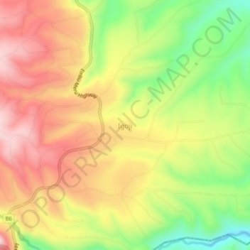
Nom : Carte topographique Igoji, altitude, relief.
Lieu : Igoji, Imenti South, Meru County, Eastern, Kenya (-0.20800 37.66085 -0.16800 37.70085)
Altitude moyenne : 1 309 m
Altitude minimum : 1 120 m
Altitude maximum : 1 470 m
Autres cartes topographiques
Cliquez sur une carte pour visualiser sa topographie, son altitude et son relief.
Baranga
Kenya > Meru County > Imenti South
Baranga, Imenti South, Meru County, Eastern, Kenya
Altitude moyenne : 1 346 m
Nkubu
Kenya > Meru County > Imenti South
Nkubu, Imenti South, Meru County, Eastern, Kenya
Altitude moyenne : 1 487 m
Mitunguu
Kenya > Meru County > Imenti South
Mitunguu, Imenti South, Meru County, Eastern, Kenya
Altitude moyenne : 1 006 m