
Carte topographique Malvern
Carte interactive
Cliquez sur la carte pour afficher l’altitude.
À propos de cette carte
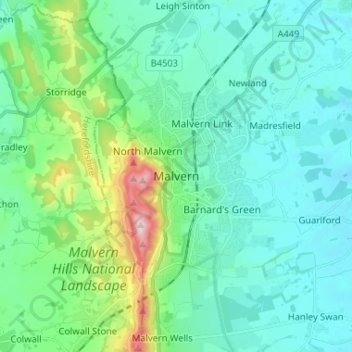
Nom : Carte topographique Malvern, altitude, relief.
Altitude moyenne : 95 m
Altitude minimum : 19 m
Altitude maximum : 423 m
Malvern lies in the Lower Severn/Avon plain affording it a degree of shelter caused by virtue of its nestling in between the Cotswold hills to the east, the Welsh Hills and Mountains to the west, and Birmingham plateau to the north. Although as with all the British Isles it has a maritime climate, the local topography means summer warmth can become emphasised by a slight foehn effect off the surrounding hills. The record maximum stands at 35.8c(96.4f) set in August 1990. Typically 17.3 days of the year will reach 25.1c(77.2f) or higher and the annual warmest day should reach 29.8c(85.6f) according to the 1971–00 observing period.
Autres cartes topographiques
Cliquez sur une carte pour visualiser sa topographie, son altitude et son relief.
Sinton Green
United Kingdom > England > Worcestershire > Malvern Hills > Grimley > Sinton Green
Sinton Green, Grimley, Malvern Hills, Worcestershire, West Midlands, England, WR2 6NW, United Kingdom
Altitude moyenne : 42 m