
Carte topographique Turpan
Carte interactive
Cliquez sur la carte pour afficher l’altitude.
À propos de cette carte
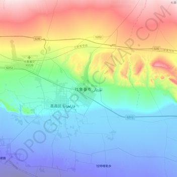
Nom : Carte topographique Turpan, altitude, relief.
Lieu : Turpan, Gaochang District, Turpan, Xinjiang, 838000, China (42.78003 89.02405 43.10003 89.34405)
Altitude moyenne : 104 m
Altitude minimum : -141 m
Altitude maximum : 626 m
Turpan is located about 150 km (93 mi) southeast of Ürümqi, Xinjiang's capital, in a mountain basin, on the northern side of the Turpan Depression, at an elevation of 30 m (98 ft) above sea level. Outside of Turpan is a small volcanic cone, the Turfan volcano, that is said to have erupted in 1120 as described in the Song Dynasty. In June 1995, a book of standard names for local geography was published.