
Faire un don
Équipez-vous pour votre prochaine aventure :
En tant que Partenaire Amazon, ce site perçoit une commission sur les achats éligibles sans surcoût pour vous.
Carte topographique Whitehorse
Cliquez sur la carte pour afficher l’altitude.
Faire un don
Équipez-vous pour votre prochaine aventure :
En tant que Partenaire Amazon, ce site perçoit une commission sur les achats éligibles sans surcoût pour vous.
Whitehorse
Whitehorse has a subarctic climate (Köppen climate classification: Dfc) and lies in the rain shadow of the Coast Mountains, causing precipitation totals to be quite low year-round. Due to the city's location in the Whitehorse valley, the climate is milder than other comparable northern communities such as Yellowknife, however during cold snaps it is not uncommon for temperatures to drop below −40 °C (−40 °F). With an average annual temperature of −0.1 °C (31.8 °F) Whitehorse is the warmest place in the Yukon. The temperature measurements for the city are taken at the airport. The Whitehorse Riverdale weather station situated at a lower elevation than the airport is even warmer at 0.2 °C (32.4 °F).
Faire un don
Équipez-vous pour votre prochaine aventure :
En tant que Partenaire Amazon, ce site perçoit une commission sur les achats éligibles sans surcoût pour vous.
À propos de cette carte
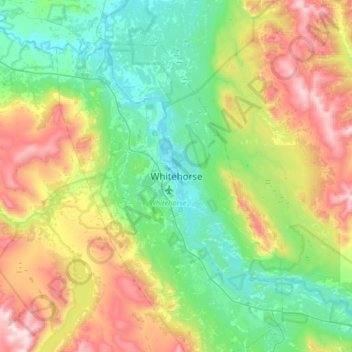
Nom : Carte topographique Whitehorse, altitude, relief.
Lieu : Whitehorse, Yukon, Canada (60.56157 -135.21493 60.88157 -134.89493)
Altitude moyenne : 1 008 m
Altitude minimum : 629 m
Altitude maximum : 1 894 m
Faire un don
Équipez-vous pour votre prochaine aventure :
En tant que Partenaire Amazon, ce site perçoit une commission sur les achats éligibles sans surcoût pour vous.
Autres cartes topographiques
Cliquez sur une carte pour visualiser sa topographie, son altitude et son relief.
Kluane National Park and Reserve
The Reserve includes the highest mountain in Canada, Mount Logan (5,959 metres or 19,551 feet) of the Saint Elias Mountains. Mountains and glaciers dominate the park's landscape, covering 83% of its area. The rest of the land in the park is forest and tundra—east of the largest mountains and glaciers—where…
Altitude moyenne : 1 536 m
Faire un don
Équipez-vous pour votre prochaine aventure :
En tant que Partenaire Amazon, ce site perçoit une commission sur les achats éligibles sans surcoût pour vous.