
Carte topographique Sanmenxia
Carte interactive
Cliquez sur la carte pour afficher l’altitude.
À propos de cette carte
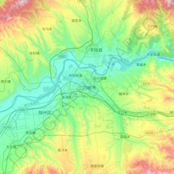
Nom : Carte topographique Sanmenxia, altitude, relief.
Altitude moyenne : 577 m
Altitude minimum : 271 m
Altitude maximum : 1 301 m
Sanmenxia is located in western Henan on the southern (right) bank of the Yellow River, and is surrounded on three sides by mountains, with elevations generally increasing from northeast to southwest. Most of the prefecture is at an altitude of 300 to 1,500 metres (980 to 4,920 ft), although the highest peak in the province, at 2,413.8 metres (7,919 ft), is located in Lingbao. The prefecture is at the intersection of Henan, Shanxi, and Shaanxi provinces, bordering Luoyang to the east, Nanyang to the south, Weinan (Shaanxi) to the west, and Yuncheng (Shanxi) to the north across the Yellow River.