
Faire un don
Équipez-vous pour votre prochaine aventure :
En tant que Partenaire Amazon, ce site perçoit une commission sur les achats éligibles sans surcoût pour vous.
Carte topographique Fort St. John
Cliquez sur la carte pour afficher l’altitude.
Faire un don
Équipez-vous pour votre prochaine aventure :
En tant que Partenaire Amazon, ce site perçoit une commission sur les achats éligibles sans surcoût pour vous.
Fort St. John
Sitting at an elevation of 690 m (2,260 ft), Fort St. John is situated within a low-lying valley near the eastern foothills of the Muskwa Ranges and Hart Ranges of the Northern Rockies. Prairies lie to the east and north, while to the west the Rocky Mountains form a rain shadow. The city is built on relatively flat, rolling hills.
Faire un don
Équipez-vous pour votre prochaine aventure :
En tant que Partenaire Amazon, ce site perçoit une commission sur les achats éligibles sans surcoût pour vous.
À propos de cette carte
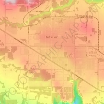
Nom : Carte topographique Fort St. John, altitude, relief.
Altitude moyenne : 676 m
Altitude minimum : 493 m
Altitude maximum : 780 m
Faire un don
Équipez-vous pour votre prochaine aventure :
En tant que Partenaire Amazon, ce site perçoit une commission sur les achats éligibles sans surcoût pour vous.
Autres cartes topographiques
Cliquez sur une carte pour visualiser sa topographie, son altitude et son relief.
Mount Hermann
Canada > British Columbia > Peace River Regional District > Tumbler Ridge
Altitude moyenne : 1 439 m
Carbon Peak
Canada > British Columbia > Peace River Regional District > Area E (Moberly Lake/Sukunka Valley)
Altitude moyenne : 1 421 m
Tsay Keh Dene Nation
Canada > British Columbia > Peace River Regional District > Area B (Finlay Valley/Beatton Valley)
Altitude moyenne : 688 m
Van Somer Point
Canada > British Columbia > Peace River Regional District > Area B (Finlay Valley/Beatton Valley)
Altitude moyenne : 670 m
Faire un don
Équipez-vous pour votre prochaine aventure :
En tant que Partenaire Amazon, ce site perçoit une commission sur les achats éligibles sans surcoût pour vous.
Black Bear Ridge
Canada > British Columbia > Peace River Regional District > Area B (Finlay Valley/Beatton Valley)
Altitude moyenne : 1 314 m
Reef Canyon
Canada > British Columbia > Peace River Regional District > Area B (Finlay Valley/Beatton Valley)
Altitude moyenne : 1 107 m
Dawson Creek
Canada > British Columbia > Peace River Regional District > Dawson Creek
Altitude moyenne : 739 m