
Carte topographique Changchun City
Carte interactive
Cliquez sur la carte pour afficher l’altitude.
À propos de cette carte
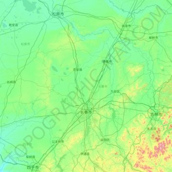
Nom : Carte topographique Changchun City, altitude, relief.
Lieu : Changchun City, Jilin, 130000, China (43.15999 124.00874 45.25134 127.08779)
Altitude moyenne : 215 m
Altitude minimum : 101 m
Altitude maximum : 1 349 m
Changchun lies in the middle portion of the Northeast China Plain. Its municipality area is located at latitude 43° 05′−45° 15′ N and longitude 124° 18′−127° 02' E. The total area of Changchun municipality is 20,571 km2 (7,943 sq mi), including metro areas of 2,583 square kilometres (997 sq mi), and a city proper area of 159 km2 (61 sq mi). The city is situated at a moderate elevation, ranging from 250 to 350 metres (820 to 1,150 ft) within its administrative region. In the eastern portion of the city, there lies a small area of low mountains, with the Laodaodong Mountain, which has an altitude of 711 meters, being the highest. The city is also situated at the crisscross point of the third east–westward "Europe-Asia Continental Bridge". Changchun prefecture is dotted with 222 rivers and lakes. The Yitong River, a small tributary of the Songhua River, runs through the city proper.
Autres cartes topographiques
Cliquez sur une carte pour visualiser sa topographie, son altitude et son relief.
Yanji
China > Jilin > Yanji City
Yanji, Yanji City, Yanbian, Jilin, 133000, China
Altitude moyenne : 314 m
Taiwang
China > Jilin > Ji'an City
Taiwang, Ji'an City, Tonghua City, Jilin, China
Altitude moyenne : 303 m
Hunjiang District
Hunjiang District, Baishan City, Jilin, 134300, China
Altitude moyenne : 708 m