
Carte topographique Koroit
Carte interactive
Cliquez sur la carte pour afficher l’altitude.
À propos de cette carte
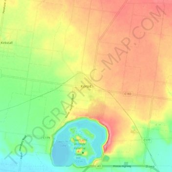
Nom : Carte topographique Koroit, altitude, relief.
Altitude moyenne : 56 m
Altitude minimum : 8 m
Altitude maximum : 104 m
Autres cartes topographiques
Cliquez sur une carte pour visualiser sa topographie, son altitude et son relief.
Tower Hill Lake
Tower Hill Lake, Lake's Edge Path, Illowa, Koroit, Shire of Moyne, Barwon South West, Victoria, 3282, Australia
Altitude moyenne : 31 m
Tower Hill Wildlife Reserve (hunting)
Tower Hill Wildlife Reserve (hunting), Entrance Road, Illowa, Koroit, Shire of Moyne, Barwon South West, Victoria, 3282, Australia
Altitude moyenne : 33 m