
Faire un don
Équipez-vous pour votre prochaine aventure :
En tant que Partenaire Amazon, ce site perçoit une commission sur les achats éligibles sans surcoût pour vous.
Carte topographique Weber County
Cliquez sur la carte pour afficher l’altitude.
Faire un don
Équipez-vous pour votre prochaine aventure :
En tant que Partenaire Amazon, ce site perçoit une commission sur les achats éligibles sans surcoût pour vous.
Weber County
The county extends from high in the Wasatch Range in the east into a portion of the Great Salt Lake to the west, where the county's elongated point exists. The Weber and Ogden rivers and their tributaries run through its valleys. The Weber County Surveyor's office divides the county into two regions, the "Lower Valley" and the "Upper Valley", divided by the ridge of the Wasatch front range south through the county. Lower Valley, adjacent to the Lake, is the county's more populous part. The Upper Valley consists mostly of the Ogden Valley, the watershed of the Ogden River. The county's highest elevation is Willard Peak in the Wasatch Mountains, at 9,763 ft (2,976 m) ASL. The county has an area of 659 square miles (1,710 km2), of which 576 square miles (1,490 km2) is land and 83 square miles (210 km2) (13%) is water. It is the second-smallest county in Utah by land area and third-smallest by total area.
Faire un don
Équipez-vous pour votre prochaine aventure :
En tant que Partenaire Amazon, ce site perçoit une commission sur les achats éligibles sans surcoût pour vous.
À propos de cette carte
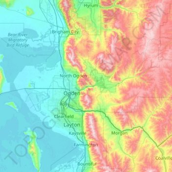
Nom : Carte topographique Weber County, altitude, relief.
Lieu : Weber County, Utah, United States (41.07684 -112.49348 41.43393 -111.42038)
Altitude moyenne : 1 722 m
Altitude minimum : 1 278 m
Altitude maximum : 2 919 m
Faire un don
Équipez-vous pour votre prochaine aventure :
En tant que Partenaire Amazon, ce site perçoit une commission sur les achats éligibles sans surcoût pour vous.
Autres cartes topographiques
Cliquez sur une carte pour visualiser sa topographie, son altitude et son relief.
Faire un don
Équipez-vous pour votre prochaine aventure :
En tant que Partenaire Amazon, ce site perçoit une commission sur les achats éligibles sans surcoût pour vous.
Salt Lake City
United States > Utah > Salt Lake County > Salt Lake City
Salt Lake City has an area of 110.4 square miles (286 km2) and an average elevation of 4,327 feet (1,319 m) above sea level. The lowest point within the boundaries of the city is 4,210 feet (1,280 m) near the Jordan River and the Great Salt Lake, and the highest is Grandview Peak, at 9,410 feet (2,868 m).
Altitude moyenne : 1 625 m
Faire un don
Équipez-vous pour votre prochaine aventure :
En tant que Partenaire Amazon, ce site perçoit une commission sur les achats éligibles sans surcoût pour vous.
Colorado Plateau
United States > Utah > San Juan County
Younger igneous rocks form spectacular topographic features. The Henry Mountains, La Sal Range, and Abajo Mountains, ranges that dominate many views in southeastern Utah, are formed about igneous rocks that were intruded in the interval from 20 to 31 million years: some igneous intrusions in these mountains…
Altitude moyenne : 1 512 m
Faire un don
Équipez-vous pour votre prochaine aventure :
En tant que Partenaire Amazon, ce site perçoit une commission sur les achats éligibles sans surcoût pour vous.