

Carte topographique Kedarnath
Cliquez sur la carte pour afficher l’altitude.
À propos de cette carte
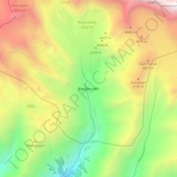
Nom : Carte topographique Kedarnath, altitude, relief.
Lieu : Kedarnath, Ukhimath, Rudraprayag, Uttarakhand, India (30.69389 79.02691 30.77389 79.10691)
Altitude moyenne : 4 208 m
Altitude minimum : 2 731 m
Altitude maximum : 6 044 m
Autres cartes topographiques
Cliquez sur une carte pour visualiser sa topographie, son altitude et son relief.

Kedarnath Wildlife Sanctuary
India > Uttarakhand > Ukhimath
Located in the Himalayan Highlands with an elevation ranging from 1,160 metres (3,810 ft) (near Phata) to the Chaukhamba peak at 7,068 m (23,189 ft), it was a notified reserve forest between 1916 and 1920. It was changed to a sanctuary on 21 January 1972, and has been designated a "Habitat/Species Management…
Altitude moyenne : 3 285 m