
Carte topographique Meridian Peak
Carte interactive
Cliquez sur la carte pour afficher l’altitude.
À propos de cette carte
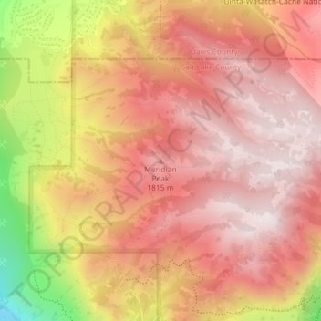
Nom : Carte topographique Meridian Peak, altitude, relief.
Altitude moyenne : 1 698 m
Altitude minimum : 1 295 m
Altitude maximum : 1 884 m
Meridian Peak can be found at the southern end of Elliot Ridge Trail. It can be reached by ascending several hiking trails into the Gore Range. Surprise Lake Trail goes south for 2.6 miles to Surprise Lake, then the Gore Range Trail continues west for 1.9 miles to a junction with the Upper Cataract Lake and Mirror Lake Trail. Mirror Lake is 6.5 miles beyond the junction, at an elevation of 10,560 feet. The Elliot Ridge Trail is 3.2 miles from Mirror Lake. The summit of Meridian Peak is another 1.2 south from the junction with the Elliot Ridge Trail.
Autres cartes topographiques
Cliquez sur une carte pour visualiser sa topographie, son altitude et son relief.
Black Mountain
United States > Utah > Salt Lake County > Salt Lake City
Black Mountain, Salt Lake City, Salt Lake County, Utah, United States
Altitude moyenne : 2 250 m
Salt Lake City
United States > Utah > Salt Lake County > Salt Lake City
Salt Lake City, Salt Lake County, Utah, 84139, United States
Altitude moyenne : 1 625 m