
Carte topographique Rendon
Carte interactive
Cliquez sur la carte pour afficher l’altitude.
À propos de cette carte
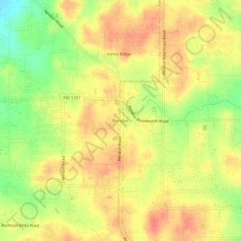
Nom : Carte topographique Rendon, altitude, relief.
Lieu : Rendon, Fort Worth, Tarrant County, Texas, United States (32.55625 -97.26140 32.59625 -97.22140)
Altitude moyenne : 221 m
Altitude minimum : 189 m
Altitude maximum : 240 m
Autres cartes topographiques
Cliquez sur une carte pour visualiser sa topographie, son altitude et son relief.
Moselle
United States > Texas > Tarrant County > Fort Worth
Moselle, Fort Worth, Tarrant County, Texas, 76134, United States
Altitude moyenne : 233 m
Fort Worth
United States > Texas > Tarrant County > Fort Worth
Fort Worth, Tarrant County, Texas, 76102, United States
Altitude moyenne : 202 m
Glenwood Park
United States > Texas > Tarrant County > Fort Worth
Glenwood Park, Fort Worth, Tarrant County, Texas, 76104, United States
Altitude moyenne : 179 m
Ederville
United States > Texas > Tarrant County > Fort Worth > Ederville
Ederville, Fort Worth, Tarrant County, Texas, 76112, United States
Altitude moyenne : 187 m