
Carte topographique Gabriola Island
Carte interactive
Cliquez sur la carte pour afficher l’altitude.
À propos de cette carte
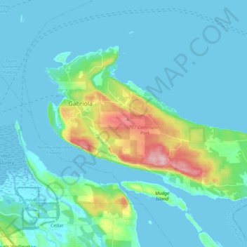
Nom : Carte topographique Gabriola Island, altitude, relief.
Altitude moyenne : 26 m
Altitude minimum : -2 m
Altitude maximum : 174 m
Gabriola is about 14 kilometres (9 mi) long by 4.2 kilometres (2.6 mi) wide on average with a land area of 57.6 square kilometres (22.2 sq mi). The topography varies from flat sandy beaches at sea level to forested hills rising to 160 metres (525 ft) on Stoney Ridge in the centre of the island.
Autres cartes topographiques
Cliquez sur une carte pour visualiser sa topographie, son altitude et son relief.
Gaviola Island
Canada > British Columbia > Regional District of Nanaimo > Area B (DeCourcy/Gabriola/Mudge)
Gaviola Island, Area B (DeCourcy/Gabriola/Mudge), Regional District of Nanaimo, British Columbia, Canada
Altitude moyenne : 3 m
Gabriola
Canada > British Columbia > Regional District of Nanaimo > Area B (DeCourcy/Gabriola/Mudge)
Gabriola, Area B (DeCourcy/Gabriola/Mudge), Regional District of Nanaimo, British Columbia, V0R 1X6, Canada
Altitude moyenne : 31 m