
Carte topographique Tallahassee
Carte interactive
Cliquez sur la carte pour afficher l’altitude.
À propos de cette carte
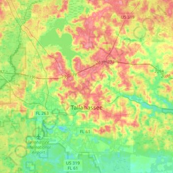
Nom : Carte topographique Tallahassee, altitude, relief.
Lieu : Tallahassee, Leon County, Florida, United States (30.34670 -84.37804 30.58724 -84.12995)
Altitude moyenne : 36 m
Altitude minimum : 2 m
Altitude maximum : 81 m
Tallahassee's terrain is hilly by Florida standards, being at the southern end of the Red Hills Region, just above the Cody Scarp. The elevation varies from near sea level to just over 200 feet (61 m), with the state capitol on one of the highest hills in the city. The city includes two large lake basins, Lake Jackson and Lake Lafayette, and borders the northern end of the Apalachicola National Forest.
Autres cartes topographiques
Cliquez sur une carte pour visualiser sa topographie, son altitude et son relief.
Belair
United States > Florida > Leon County > Belair
Belair, Leon County, Florida, 32305-7804, United States
Altitude moyenne : 18 m