
Carte topographique League City
Carte interactive
Cliquez sur la carte pour afficher l’altitude.
À propos de cette carte
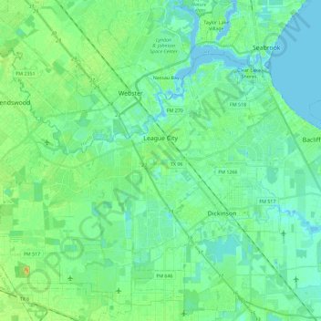
Nom : Carte topographique League City, altitude, relief.
Lieu : League City, Galveston County, Texas, 77573, United States (29.42775 -95.22547 29.55908 -94.99763)
Altitude moyenne : 7 m
Altitude minimum : -4 m
Altitude maximum : 23 m
Autres cartes topographiques
Cliquez sur une carte pour visualiser sa topographie, son altitude et son relief.
Texas City
United States > Texas > Galveston County
Texas City, Galveston County, Texas, United States
Altitude moyenne : 2 m
Max's Creek
United States > Texas > Galveston County > Friendswood
Max's Creek, West Ranch, Friendswood, Galveston County, Texas, United States
Altitude moyenne : 10 m
Dickinson
United States > Texas > Galveston County
Dickinson, Galveston County, Texas, 77539, United States
Altitude moyenne : 6 m
League City
United States > Texas > Galveston County > League City > League City
League City, Galveston County, Texas, 77573, United States
Altitude moyenne : 7 m
Kemah
United States > Texas > Galveston County > Kemah
Kemah, Galveston County, Texas, United States
Altitude moyenne : 5 m
Galveston
United States > Texas > Galveston County > Galveston
Galveston, Galveston County, Texas, 77553, United States
Altitude moyenne : 1 m
Galveston
United States > Texas > Galveston County
Galveston, Galveston County, Texas, United States
Altitude moyenne : 1 m
Friendswood
United States > Texas > Galveston County
Friendswood, Galveston County, Texas, 77546, United States
Altitude moyenne : 11 m