
Carte topographique Keats Island
Carte interactive
Cliquez sur la carte pour afficher l’altitude.
À propos de cette carte
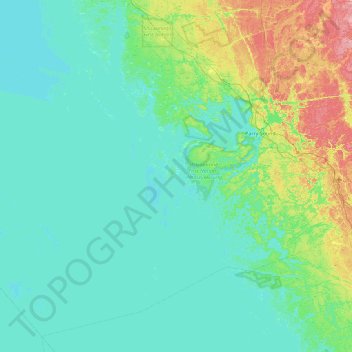
Nom : Carte topographique Keats Island, altitude, relief.
Altitude moyenne : 194 m
Altitude minimum : 171 m
Altitude maximum : 311 m
Autres cartes topographiques
Cliquez sur une carte pour visualiser sa topographie, son altitude et son relief.
Bayfield Inlet
Canada > Ontario > The Archipelago Township
Bayfield Inlet, The Archipelago Township, Parry Sound District, Central Ontario, Ontario, Canada
Altitude moyenne : 181 m
The Archipelago Township
Canada > Ontario > The Archipelago Township
The Archipelago Township, Parry Sound District, Central Ontario, Ontario, P0G 1K0, Canada
Altitude moyenne : 204 m
Naiscoot Lake
Canada > Ontario > The Archipelago Township
Naiscoot Lake, The Archipelago Township, Parry Sound District, Central Ontario, Ontario, Canada
Altitude moyenne : 211 m
Lumsden Island
Canada > Ontario > The Archipelago Township
Lumsden Island, The Archipelago Township, Parry Sound District, Central Ontario, Ontario, Canada
Altitude moyenne : 199 m
Hurontario Island
Canada > Ontario > The Archipelago Township
Hurontario Island, The Archipelago Township, Parry Sound District, Central Ontario, Ontario, Canada
Altitude moyenne : 197 m
Pike Bay
Canada > Ontario > The Archipelago Township
Pike Bay, Nares Inlet Road, The Archipelago Township, Parry Sound District, Central Ontario, Ontario, Canada
Altitude moyenne : 178 m
Brewery Lake
Canada > Ontario > The Archipelago Township
Brewery Lake, Dumont Road, The Archipelago Township, Parry Sound District, Central Ontario, Ontario, Canada
Altitude moyenne : 217 m