
Carte topographique Whakatāne District
Carte interactive
Cliquez sur la carte pour afficher l’altitude.
À propos de cette carte
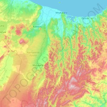
Nom : Carte topographique Whakatāne District, altitude, relief.
Lieu : Whakatāne District, Bay of Plenty, Nouvelle-Zélande (-38.85596 176.47628 -37.82942 177.23950)
Altitude moyenne : 416 m
Altitude minimum : 0 m
Altitude maximum : 1 365 m
Autres cartes topographiques
Cliquez sur une carte pour visualiser sa topographie, son altitude et son relief.
Parinui
Nouvelle-Zélande > Bay of Plenty > Ōpōtiki District
Parinui, Ōpōtiki District, Bay of Plenty, 3162, Nouvelle-Zélande
Altitude moyenne : 67 m
Lake Ōkataina
Nouvelle-Zélande > Bay of Plenty > Ruato
Lake Ōkataina, Eastern Okataina Walkway, Ruato, Rotorua District, Bay of Plenty, Nouvelle-Zélande
Altitude moyenne : 440 m
Tauranga City
Nouvelle-Zélande > Bay of Plenty
Tauranga City, Bay of Plenty, Nouvelle-Zélande
Altitude moyenne : 55 m
Rotorua
Nouvelle-Zélande > Bay of Plenty > Rotorua
Rotorua, Rotorua District, Bay of Plenty, 3010, Nouvelle-Zélande
Altitude moyenne : 435 m
Mount Tarawera
Nouvelle-Zélande > Bay of Plenty > Rotorua
Mount Tarawera, Rotorua, Rotorua District, Bay of Plenty, Nouvelle-Zélande
Altitude moyenne : 894 m
Rotorua District
Nouvelle-Zélande > Bay of Plenty
Rotorua District, Bay of Plenty, Nouvelle-Zélande
Altitude moyenne : 404 m