
Carte topographique Bury Knowle Park
Carte interactive
Cliquez sur la carte pour afficher l’altitude.
À propos de cette carte
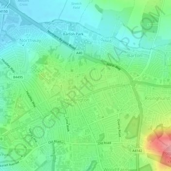
Nom : Carte topographique Bury Knowle Park, altitude, relief.
Altitude moyenne : 94 m
Altitude minimum : 60 m
Altitude maximum : 172 m
Autres cartes topographiques
Cliquez sur une carte pour visualiser sa topographie, son altitude et son relief.
Headington Hill Park
United Kingdom > England > Oxford
Headington Hill Park, New Marston, Oxford, Oxfordshire, South East, England, United Kingdom
Altitude moyenne : 74 m
Binsey
United Kingdom > England > Oxford > Binsey
Binsey, Oxford, Oxfordshire, South East England, England, OX2 0NG, United Kingdom
Altitude moyenne : 69 m
Blackbird Leys
United Kingdom > England > Oxford
Blackbird Leys, Oxford, Oxfordshire, South East, England, United Kingdom
Altitude moyenne : 68 m
Angel and Greyhound Meadow
United Kingdom > England > Oxford
Angel and Greyhound Meadow, New Marston, Oxford, Oxfordshire, South East, England, United Kingdom
Altitude moyenne : 68 m
Godstow
United Kingdom > England > Oxford > Godstow
Godstow, Oxford, Oxfordshire, South East, England, OX2 8PN, United Kingdom
Altitude moyenne : 71 m
Hinksey Stream
United Kingdom > England > Oxford
Hinksey Stream, Oxford, Oxfordshire, South East, England, OX1 4SY, United Kingdom
Altitude moyenne : 65 m
Risinghurst and Sandhills
United Kingdom > England > Oxford
Risinghurst and Sandhills, Oxford, Oxfordshire, South East, England, United Kingdom
Altitude moyenne : 107 m
Castle Mill Stream
United Kingdom > England > Oxford
Castle Mill Stream, Oxford, Oxfordshire, South East, England, OX1 1HF, United Kingdom
Altitude moyenne : 61 m