
Carte topographique Isle Royale
Carte interactive
Cliquez sur la carte pour afficher l’altitude.
À propos de cette carte
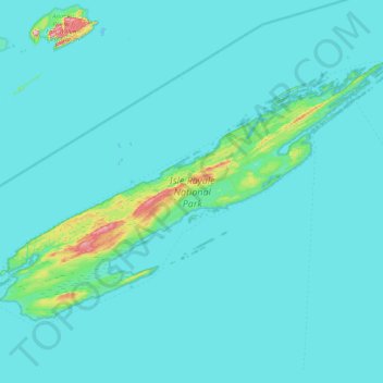
Nom : Carte topographique Isle Royale, altitude, relief.
Lieu : Isle Royale, Keweenaw County, Michigan, United States (47.82376 -89.23555 48.19102 -88.42232)
Altitude moyenne : 190 m
Altitude minimum : 176 m
Altitude maximum : 443 m
According to the Köppen climate classification system, Isle Royale National Park has a mild summer Humid continental climate (Dfb). According to the United States Department of Agriculture, the Plant Hardiness zone is 4b at 1178 ft (359 m) elevation with an average annual extreme minimum temperature of -24.2 °F (-31.2 °C).
Autres cartes topographiques
Cliquez sur une carte pour visualiser sa topographie, son altitude et son relief.
Eagle Harbor Township
United States > Michigan > Keweenaw County
Eagle Harbor Township, Keweenaw County, Michigan, United States
Altitude moyenne : 190 m
Mohawk
United States > Michigan > Keweenaw County
Mohawk, Allouez Township, Keweenaw County, Michigan, 49901, United States
Altitude moyenne : 300 m
Eagle Harbor
United States > Michigan > Keweenaw County
Eagle Harbor, Eagle Harbor Township, Keweenaw County, Michigan, United States
Altitude moyenne : 200 m
Allouez
United States > Michigan > Keweenaw County
Allouez, Allouez Township, Keweenaw County, Michigan, 49805, United States
Altitude moyenne : 301 m
Isle Royale National Park
United States > Michigan > Keweenaw County
Isle Royale National Park, Keweenaw County, Michigan, United States
Altitude moyenne : 189 m
Gay
United States > Michigan > Keweenaw County > Gay
Gay, Sherman Township, Keweenaw County, Michigan, United States
Altitude moyenne : 188 m
Copper Harbor
United States > Michigan > Keweenaw County
Copper Harbor, Grant Township, Keweenaw County, Michigan, 49918, United States
Altitude moyenne : 220 m