
Carte topographique Grand Rapids
Carte interactive
Cliquez sur la carte pour afficher l’altitude.
À propos de cette carte
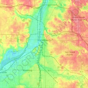
Nom : Carte topographique Grand Rapids, altitude, relief.
Lieu : Grand Rapids, Kent County, Michigan, United States (42.88365 -85.75153 43.02905 -85.56865)
Altitude moyenne : 216 m
Altitude minimum : 178 m
Altitude maximum : 257 m
Grand Rapids developed on the banks of the Grand River, where there was once a set of rapids, at an altitude of 610 feet (186 m) above sea level. Ships could navigate on the river up to this fall line, stopping because of the rapids. The river valley is flat and narrow, surrounded by steep hills and bluffs. The terrain becomes more rolling hills away from the river. The countryside surrounding the metropolitan area consists of mixed forest and farmland, with large areas of orchards to the northwest. It is approximately 25 mi (40 km) east of Lake Michigan. The state capital of Lansing lies about 60 mi (97 km) to the east-by-southeast, and Kalamazoo is about 50 mi (80 km) to the south.
Autres cartes topographiques
Cliquez sur une carte pour visualiser sa topographie, son altitude et son relief.
Richmond Park
United States > Michigan > Kent County > Grand Rapids
Richmond Park, Grand Rapids, Kent County, Michigan, United States
Altitude moyenne : 202 m
Kent City
United States > Michigan > Kent County
Kent City, Tyrone Township, Kent County, Michigan, United States
Altitude moyenne : 251 m
Sand Lake
United States > Michigan > Kent County
Sand Lake, Nelson Township, Kent County, Michigan, United States
Altitude moyenne : 277 m
Comstock Park
United States > Michigan > Kent County > Plainfield Charter Township
Comstock Park, Plainfield Charter Township, Kent County, Michigan, United States
Altitude moyenne : 206 m
Cascade Charter Township
United States > Michigan > Kent County
Cascade Charter Township, Kent County, Michigan, 49546, United States
Altitude moyenne : 229 m
Byron Township
United States > Michigan > Kent County
Byron Township, Kent County, Michigan, United States
Altitude moyenne : 221 m
Creekside Park
United States > Michigan > Kent County > Lowell
Creekside Park, Lowell, Kent County, Michigan, 49331, United States
Altitude moyenne : 201 m
Sparta
United States > Michigan > Kent County
Sparta, Sparta Township, Kent County, Michigan, United States
Altitude moyenne : 235 m
Rockford
United States > Michigan > Kent County
Rockford, Kent County, Michigan, 49351, United States
Altitude moyenne : 239 m
Cedar Springs
United States > Michigan > Kent County
Cedar Springs, Kent County, Michigan, 49319, United States
Altitude moyenne : 262 m
Sparta Township
United States > Michigan > Kent County
Sparta Township, Kent County, Michigan, 49345, United States
Altitude moyenne : 246 m
Lowell
United States > Michigan > Kent County
Lowell, Kent County, Michigan, United States
Altitude moyenne : 206 m
Kentwood
United States > Michigan > Kent County
Kentwood, Kent County, Michigan, United States
Altitude moyenne : 216 m