
Carte topographique Iowa City
Carte interactive
Cliquez sur la carte pour afficher l’altitude.
À propos de cette carte
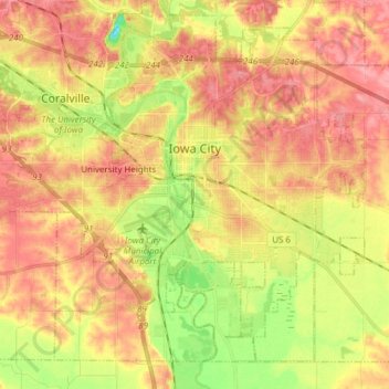
Nom : Carte topographique Iowa City, altitude, relief.
Lieu : Iowa City, Johnson County, Iowa, United States (41.59855 -91.61579 41.69663 -91.46306)
Altitude moyenne : 216 m
Altitude minimum : 163 m
Altitude maximum : 254 m
The elevation at the Iowa City Municipal Airport is 668 ft (203.6 m) above sea level.
Autres cartes topographiques
Cliquez sur une carte pour visualiser sa topographie, son altitude et son relief.
Tiffin
United States > Iowa > Johnson County
Tiffin, Johnson County, Iowa, 52340, United States
Altitude moyenne : 227 m
Coralville
United States > Iowa > Johnson County
Coralville, Johnson County, Iowa, 52241, United States
Altitude moyenne : 224 m
North Liberty
United States > Iowa > Johnson County
North Liberty, Johnson County, Iowa, 52317, United States
Altitude moyenne : 235 m
Iowa City
United States > Iowa > Johnson County > Iowa City
Iowa City, Johnson County, Iowa, 52240-5544, United States
Altitude moyenne : 225 m
Hills
United States > Iowa > Johnson County
Hills, Johnson County, Iowa, 52235, United States
Altitude moyenne : 196 m