
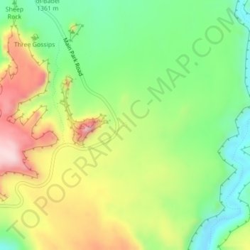
Carte topographique La Sal Mountains Viewpoint
Carte interactive
Cliquez sur la carte pour afficher l’altitude.
À propos de cette carte
Nom : Carte topographique La Sal Mountains Viewpoint, altitude, relief.
Altitude moyenne : 1 347 m
Altitude minimum : 1 217 m
Altitude maximum : 1 522 m
Autres cartes topographiques
Cliquez sur une carte pour visualiser sa topographie, son altitude et son relief.
Grand Staircase-Escalante National Monument
Grand Staircase-Escalante National Monument, Left Hand Collet Road, Kane County, Utah, USA
Altitude moyenne : 1 857 m
Antelope Island State Park
Antelope Island State Park, Antelope Island Road, Davis County, Utah, USA
Altitude moyenne : 1 314 m
Glen Canyon National Recreation Area
Glen Canyon National Recreation Area, Moody Creek Road, Garfield County, Utah, USA
Altitude moyenne : 1 798 m
Timpanogos Glacier
USA > Utah > Aspen Grove
Timpanogos Glacier, Mount Timpanogos Trail #052, Aspen Grove, Utah County, Utah, USA
Altitude moyenne : 3 148 m
Fishlake National Forest
Fishlake National Forest, US Forest Service Road 1782, Garfield County, Utah, USA
Altitude moyenne : 2 075 m
Lake Fork River
Lake Fork River, Duchesne County, Utah, 84001, USA
Altitude moyenne : 1 992 m