
Carte topographique Romford
Carte interactive
Cliquez sur la carte pour afficher l’altitude.
À propos de cette carte
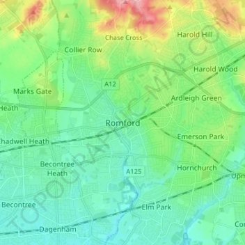
Nom : Carte topographique Romford, altitude, relief.
Lieu : Romford, Greater London, England, RM1 1RX, United Kingdom (51.53605 0.14226 51.61605 0.22226)
Altitude moyenne : 29 m
Altitude minimum : 1 m
Altitude maximum : 109 m
The town centre is about 50 feet (15 m) above sea level on a gravel terrace rising from the River Thames. The north of the town has developed on London Clay and is situated as much as 150 ft (46 m) above sea level. A continuous gentle rise in the eastern suburbs towards Gidea Park and Harold Wood peaks around 177 feet (54 m) around the Harold Court. On the northern side, Harold Hill peaks at 75 m (246 ft). The semi-rural area north of Collier Row and Harold Hill consists of many rolls of hills, with elevation peaking at the village of Havering-atte-Bower, 344 feet (105 m). The town centre is for the most part contained within a ring road formed of St Edwards Way, Mercury Gardens, Thurloe Gardens, Oldchurch Road and Waterloo Road. The market place and much of South Street and the High Street are pedestrianised. The railway cuts through the town from east to west on a viaduct, with the bulk of the central Romford area to its north. The River Rom flows through the town in underground channels and joins the Thames after flowing through Hornchurch; elsewhere along its course it is known as the River Beam and forms part of the strategic waterways Blue Ribbon Network. Romford has formed part of the continuously built-up area of London since the 1930s and is contiguous with Rush Green to the west, Collier Row to the north, Gidea Park to the east and Hornchurch to the south east.
Autres cartes topographiques
Cliquez sur une carte pour visualiser sa topographie, son altitude et son relief.
London
United Kingdom > England > London
London, Greater London, England, SW1A 2DX, United Kingdom
Altitude moyenne : 42 m
London
London, Greater London, England, United Kingdom
Altitude moyenne : 66 m
Bristol
United Kingdom > England > City of Bristol
Bristol, City of Bristol, West of England, England, United Kingdom
Altitude moyenne : 55 m
Somerset
Somerset, South West England, England, United Kingdom
Altitude moyenne : 87 m
Nottingham
United Kingdom > England > Nottinghamshire
Nottingham, England, United Kingdom
Altitude moyenne : 56 m
Dorset
United Kingdom > England > Talbot Village
Dorset, Alder Road, Branksome, Talbot Village, Bournemouth, Christchurch and Poole, South West England, England, BH12 5BJ, United Kingdom
Altitude moyenne : 57 m
Newcastle upon Tyne
Newcastle upon Tyne, North of Tyne, England, United Kingdom
Altitude moyenne : 57 m
North Yorkshire
North Yorkshire, Yorkshire and the Humber, England, United Kingdom
Altitude moyenne : 153 m
Liverpool
Liverpool, Liverpool City Region, England, United Kingdom
Altitude moyenne : 26 m
Sheffield
Sheffield, South Yorkshire, England, United Kingdom
Altitude moyenne : 168 m
Huddersfield
United Kingdom > England > Kirklees
Huddersfield, Kirklees, West Yorkshire, England, HD1 2AA, United Kingdom
Altitude moyenne : 145 m
Coventry
Coventry, West Midlands Combined Authority, England, United Kingdom
Altitude moyenne : 99 m
Stockport
Stockport, Greater Manchester, England, United Kingdom
Altitude moyenne : 95 m
North Norfolk
United Kingdom > England > Norfolk
North Norfolk, Norfolk, England, United Kingdom
Altitude moyenne : 26 m
Greater Manchester
Greater Manchester, England, United Kingdom
Altitude moyenne : 141 m
Winchester
United Kingdom > England > Hampshire
Winchester, Hampshire, England, United Kingdom
Altitude moyenne : 73 m
Norwich
United Kingdom > England > Norfolk
Norwich, Norfolk, England, United Kingdom
Altitude moyenne : 28 m
Plymouth
United Kingdom > England > Devon > Plymouth
Plymouth, Devon, South West England, England, PL1 1HH, United Kingdom
Altitude moyenne : 81 m
Kent
United Kingdom > England > Sevenoaks
Kent, Beechenlea Lane, Swanley, Sevenoaks, Kent, South East, England, BR8 7PR, United Kingdom
Altitude moyenne : 37 m
Wallington
United Kingdom > England > Northumberland
Wallington, Wallington Demesne, Northumberland, North of Tyne, England, NE61 4AR, United Kingdom
Altitude moyenne : 161 m
Lincolnshire
Lincolnshire, East Midlands, England, United Kingdom
Altitude moyenne : 28 m
Skipton
United Kingdom > England > Skipton
Skipton, North Yorkshire, Yorkshire and the Humber, England, BD23 1DU, United Kingdom
Altitude moyenne : 201 m
Tonbridge
United Kingdom > England > Kent > Tonbridge and Malling
Tonbridge, Tonbridge and Malling, Kent, England, TN9 2AN, United Kingdom
Altitude moyenne : 55 m
Corby
United Kingdom > England > North Northamptonshire > Corby
Corby, North Northamptonshire, East Midlands, England, United Kingdom
Altitude moyenne : 98 m
Ipswich
United Kingdom > England > Suffolk
Ipswich, Suffolk, England, United Kingdom
Altitude moyenne : 29 m
Brighton
United Kingdom > England > Brighton and Hove
Brighton, Brighton and Hove, England, United Kingdom
Altitude moyenne : 64 m
Copt Hewick
United Kingdom > England > North Yorkshire
Copt Hewick, North Yorkshire, England, United Kingdom
Altitude moyenne : 39 m
Fenland
United Kingdom > England > Cambridgeshire > Fenland
Fenland, Cambridgeshire, East of England, England, United Kingdom
Altitude moyenne : 4 m
Warminster
United Kingdom > England > Wiltshire
Warminster, Wiltshire, England, United Kingdom
Altitude moyenne : 143 m
West Midlands
United Kingdom > England > Warwickshire
West Midlands, Warwickshire, West Midlands Combined Authority, England, United Kingdom
Altitude moyenne : 113 m
Cambridgeshire
Cambridgeshire, Cambridgeshire and Peterborough, England, United Kingdom
Altitude moyenne : 32 m
Grimsby
United Kingdom > England > North East Lincolnshire
Grimsby, North East Lincolnshire, England, DN31 1NR, United Kingdom
Altitude moyenne : 6 m
Hebden Bridge
United Kingdom > England > Calderdale
Hebden Bridge, Calderdale, West Yorkshire, England, HX7 8AT, United Kingdom
Altitude moyenne : 277 m
Tamworth
United Kingdom > England > Staffordshire
Tamworth, Staffordshire, England, United Kingdom
Altitude moyenne : 76 m
Woking
United Kingdom > England > Surrey
Woking, Surrey, England, United Kingdom
Altitude moyenne : 38 m
Lancaster
United Kingdom > England > Lancashire
Lancaster, Lancashire, England, United Kingdom
Altitude moyenne : 84 m
Cambridge
United Kingdom > England > Cambridge
Cambridge, Cambridgeshire, East of England, England, United Kingdom
Altitude moyenne : 18 m
Bedford
United Kingdom > England > Bedford
Bedford, England, MK40 1SU, United Kingdom
Altitude moyenne : 37 m
Bournemouth
United Kingdom > England > Bournemouth, Christchurch and Poole > Wick
Bournemouth, Wick, Bournemouth, Christchurch and Poole, England, United Kingdom
Altitude moyenne : 17 m
Spalding
United Kingdom > England > Lincolnshire > South Holland
Spalding, South Holland, Lincolnshire, England, United Kingdom
Altitude moyenne : 4 m
Guildford
United Kingdom > England > Surrey
Guildford, Surrey, England, United Kingdom
Altitude moyenne : 74 m
Poole
United Kingdom > England > Bournemouth, Christchurch and Poole > Merley
Poole, Merley, Bournemouth, Christchurch and Poole, England, United Kingdom
Altitude moyenne : 23 m
West Lutton
United Kingdom > England > North Yorkshire
West Lutton, North Yorkshire, England, YO17 8TA, United Kingdom
Altitude moyenne : 111 m