
Carte topographique Farnborough
Carte interactive
Cliquez sur la carte pour afficher l’altitude.
À propos de cette carte
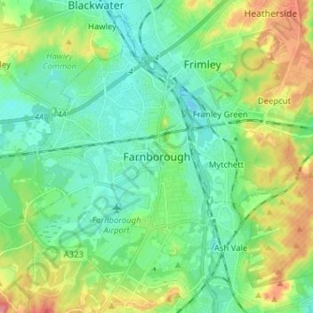
Nom : Carte topographique Farnborough, altitude, relief.
Altitude moyenne : 82 m
Altitude minimum : 57 m
Altitude maximum : 137 m
Autres cartes topographiques
Cliquez sur une carte pour visualiser sa topographie, son altitude et son relief.
Aldershot
United Kingdom > England > Hampshire > Rushmoor
Aldershot, Rushmoor, Hampshire, England, GU11 1BX, United Kingdom
Altitude moyenne : 92 m
Cargate Hill
United Kingdom > England > Hampshire > Rushmoor
Cargate Hill, Rushmoor, Hampshire, South East England, England, GU11 3AA, United Kingdom
Altitude moyenne : 100 m
Normandy Barracks
United Kingdom > England > Hampshire > Rushmoor > Farnborough
Normandy Barracks, North Camp, Farnborough, Rushmoor, Hampshire, South East England, England, GU11 2LZ, United Kingdom
Altitude moyenne : 76 m
Thorn Hill
United Kingdom > England > Hampshire > Rushmoor
Thorn Hill, Rushmoor, Hampshire, South East England, England, GU11 2DD, United Kingdom
Altitude moyenne : 82 m
The Crescent
United Kingdom > England > Hampshire > Rushmoor > Farnborough
The Crescent, Farnborough, Rushmoor, Hampshire, England, GU14 0FT, United Kingdom
Altitude moyenne : 70 m