
Carte topographique Connecticut
Carte interactive
Cliquez sur la carte pour afficher l’altitude.
À propos de cette carte
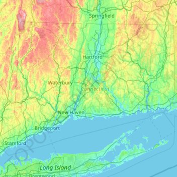
Nom : Carte topographique Connecticut, altitude, relief.
Lieu : Connecticut, United States (40.95098 -73.72781 42.05058 -71.78724)
Altitude moyenne : 118 m
Altitude minimum : -3 m
Altitude maximum : 780 m
Winters (December through mid-March) are generally cold from south to north in Connecticut. The coldest month (January) has average high temperatures ranging from 38 °F (3 °C) in the coastal lowlands to 33 °F (1 °C) in the inland and northern portions on the state. The lowest temperature recorded in Connecticut is −32 °F (−36 °C) which has been observed twice: in Falls Village on February 16, 1943, and in Coventry on January 22, 1961. The average yearly snowfall ranges from about 60 inches (1,500 mm) in the higher elevations of the northern portion of the state to only 20–25 inches (510–640 mm) along the southeast coast of Connecticut (Branford to Groton). Generally, any locale north or west of Interstate 84 receives the most snow, during a storm, and throughout the season. Most of Connecticut has less than 60 days of snow cover. Snow usually falls from late November to late March in the northern part of the state, and from early December to mid-March in the southern and coastal parts of the state.
Autres cartes topographiques
Cliquez sur une carte pour visualiser sa topographie, son altitude et son relief.
Madison
United States > Wisconsin > Dane County
Madison, Dane County, Wisconsin, United States
Altitude moyenne : 284 m
Jacksonville
United States > Florida > Duval County
Jacksonville, Duval County, Florida, United States
Altitude moyenne : 10 m
Brooklyn
United States > New York > New York
Brooklyn, Kings County, New York, United States
Altitude moyenne : 9 m
Staten Island
United States > New York > New York
Staten Island, Richmond County, New York, United States
Altitude moyenne : 9 m
Lancaster County
Lancaster County, Pennsylvania, United States
Altitude moyenne : 158 m
Sarasota
United States > Florida > Sarasota County
Sarasota, Sarasota County, Florida, United States
Altitude moyenne : 7 m
Fairfax County
Fairfax County, Virginia, United States
Altitude moyenne : 75 m
Allegheny County
Allegheny County, Pennsylvania, United States
Altitude moyenne : 325 m
Appalachian Mountains
United States > North Carolina > Yancey County
Appalachian Mountains, Yancey County, North Carolina, United States
Altitude moyenne : 1 463 m
Boulder
United States > Colorado > Boulder County
Boulder, Boulder County, Colorado, United States
Altitude moyenne : 1 785 m
Seattle
United States > Washington > King County
Seattle, King County, Washington, United States
Altitude moyenne : 40 m
Miami-Dade County
Miami-Dade County, Florida, United States
Altitude moyenne : 3 m
Spokane
United States > Washington > Spokane County
Spokane, Spokane County, Washington, United States
Altitude moyenne : 655 m
Central Park
United States > New York > New York County > New York
Central Park, New York County, New York, United States
Altitude moyenne : 26 m
Rudyard
United States > Michigan > Chippewa County
Rudyard, Rudyard Township, Chippewa County, Michigan, United States
Altitude moyenne : 209 m
Taos
United States > New Mexico > Taos County
Taos, Taos County, New Mexico, United States
Altitude moyenne : 2 180 m
Puget Sound
United States > Washington > Edmonds
Puget Sound, Admiral Way, Edmonds, Snohomish County, Washington, 98020, United States
Altitude moyenne : 0 m
Santa Fe
United States > New Mexico > Santa Fe County
Santa Fe, Santa Fe County, New Mexico, United States
Altitude moyenne : 2 221 m