
Carte topographique Pathankot
Carte interactive
Cliquez sur la carte pour afficher l’altitude.
À propos de cette carte
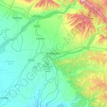
Nom : Carte topographique Pathankot, altitude, relief.
Altitude moyenne : 379 m
Altitude minimum : 257 m
Altitude maximum : 782 m
Pathankot has an average elevation of 332 metres (1,089 ft). It is a green town surrounded by the Ravi and Chakki rivers. Shiwalik foothills on the south and east and snow-capped Himalayas in the back drop in north.