
Carte topographique Felton
Carte interactive
Cliquez sur la carte pour afficher l’altitude.
À propos de cette carte
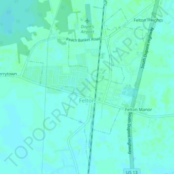
Nom : Carte topographique Felton, altitude, relief.
Lieu : Felton, Kent County, Delaware, United States (38.99828 -75.58997 39.02272 -75.56590)
Altitude moyenne : 18 m
Altitude minimum : 15 m
Altitude maximum : 21 m
Autres cartes topographiques
Cliquez sur une carte pour visualiser sa topographie, son altitude et son relief.
Camden
United States > Delaware > Kent County
Camden, Kent County, Delaware, United States
Altitude moyenne : 13 m
Holletts Corners
United States > Delaware > Kent County
Holletts Corners, Kent County, Delaware, United States
Altitude moyenne : 21 m
Woodstock Court
United States > Delaware > Kent County > Dover
Woodstock Court, Dover, Kent County, Delaware, 19904, United States
Altitude moyenne : 13 m
Lake Bernard
United States > Delaware > Kent County > Florence
Lake Bernard, Florence, Kent County, Delaware, United States
Altitude moyenne : 4 m
Marydel
United States > Delaware > Kent County
Marydel, Kent County, Delaware, 19964, United States
Altitude moyenne : 19 m
Cheswold
United States > Delaware > Kent County
Cheswold, Kent County, Delaware, 19936, United States
Altitude moyenne : 13 m
Harrington
United States > Delaware > Kent County
Harrington, Kent County, Delaware, United States
Altitude moyenne : 17 m
Cheswold
United States > Delaware > Kent County > Cheswold
Cheswold, Kent County, Delaware, 19936, United States
Altitude moyenne : 13 m
Tidbury Manor
United States > Delaware > Kent County > Tidbury Manor
Tidbury Manor, Kent County, Delaware, 19901:19962, United States
Altitude moyenne : 8 m
Dover
United States > Delaware > Kent County
Dover, Kent County, Delaware, United States
Altitude moyenne : 10 m