Géolocaliser

Carte topographique Kerala

Carte interactive

Cliquez sur la carte pour afficher l’altitude.

À propos de cette carte

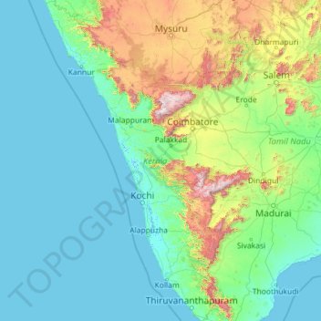
Nom : Carte topographique Kerala, altitude, relief.

Lieu : Kerala, India (8.29353 74.86407 12.79606 77.41236)

Altitude moyenne : 251 m

Altitude minimum : -4 m

Altitude maximum : 2 557 m

Kerala was alternatively called Malabar in the foreign trade circles. Earlier, the term Malabar had also been used to denote Tulu Nadu and Kanyakumari which lie contiguous to Kerala on the southwestern coast of India, in addition to the modern state of Kerala. The people of Malabar were known as Malabars. Until the arrival of the East India Company, the term Malabar was used as a general name for Kerala, along with the term Kerala. From the time of Cosmas Indicopleustes (6th century CE) itself, the Arab sailors used to call Kerala as Male. The first element of the name, however, is attested already in the Topography written by Cosmas Indicopleustes. This mentions a pepper emporium called Male, which clearly gave its name to Malabar ('the country of Male'). The name Male is thought to come from the Malayalam word Mala ('hill'). Al-Biruni (973–1048 CE) is the first known writer to call this country Malabar. Authors such as Ibn Khordadbeh and Al-Baladhuri mention Malabar ports in their works. The Arab writers had called this place Malibar, Manibar, Mulibar, and Munibar. Malabar is reminiscent of the word Malanad which means the land of hills. According to William Logan, the word Malabar comes from a combination of the Malayalam word Mala (hill) and the Persian/Arabic word Barr (country/continent).

Wikipedia (CC-BY-SA 3.0)

Autres cartes topographiques

Cliquez sur une carte pour visualiser sa topographie, son altitude et son relief.

Gujarat

India

Gujarat, India

Altitude moyenne : 137 m

Hyderabad

India > Telangana > Bahadurpura mandal

Hyderabad, Bahadurpura mandal, Hyderabad District, Telangana, India

Altitude moyenne : 549 m

Mumbai

India > Maharashtra > Mumbai

Mumbai, Maharashtra, India

Altitude moyenne : 18 m

Pune

India > Maharashtra > Pune City > Pune

Pune, Pune City, Pune District, Maharashtra, 411001, India

Altitude moyenne : 641 m

Chennai

India > Tamil Nadu > Chennai

Chennai, Chennai District, Tamil Nadu, India

Altitude moyenne : 8 m

Thanjavur

India > Tamil Nadu > Thanjavur

Thanjavur, Thanjavur District, Tamil Nadu, 613001, India

Altitude moyenne : 49 m

Tamil Nadu

India

Tamil Nadu, India

Altitude moyenne : 253 m

Jammu and Kashmir

India

Jammu and Kashmir, India

Altitude moyenne : 2 430 m

Oddapalem

India > Andhra Pradesh > Muthukur > Oddapalem

Oddapalem, Muthukur, Sri Potti Sriramulu Nellore, Andhra Pradesh, 524346, India

Altitude moyenne : 8 m

gehunlad

India > Uttarakhand > Chaubatta Khal

gehunlad, Chaubatta Khal, Pauri Garhwal District, Uttarakhand, India

Altitude moyenne : 1 625 m

Clappana

India > Kerala > Karunagappally

Clappana, Karunagappally, Kollam District, Kerala, 690525, India

Altitude moyenne : 5 m

Hubli

India > Karnataka > Hubballi Urban Taluku

Hubli, Hubballi Urban Taluku, Dharwad District, Karnataka, 580020, India

Altitude moyenne : 626 m

Mangaluru

India > Karnataka > Mangaluru taluk

Mangaluru, Mangaluru taluk, Dakshina Kannada District, Karnataka, 575001, India

Altitude moyenne : 25 m

Anaikatti

India > Tamil Nadu > Coimbatore North

Anaikatti, Mannarkad, Palakkad District, Kerala, 678741, India

Altitude moyenne : 623 m

Samethanahalli

India > Karnataka > Hosakote taluk

Samethanahalli, Hosakote taluk, Bengaluru Rural, Karnataka, 560117, India

Altitude moyenne : 868 m

Delhi

India > Delhi > Kotwali Tehsil

Delhi, Kotwali Tehsil, Central Delhi, Delhi, 110006, India

Altitude moyenne : 216 m

Guwahati

India > Assam > Guwahati

Guwahati, Kamrup Metropolitan, Assam, 781015, India

Altitude moyenne : 113 m

Coimbatore district

India > Tamil Nadu

Coimbatore district, Tamil Nadu, India

Altitude moyenne : 552 m

Bangalore Urban

India > Karnataka

Bangalore Urban, Karnataka, India

Altitude moyenne : 856 m

Siliguri

India > West Bengal > Siliguri Subdivsion

Siliguri, Siliguri Subdivsion, Darjeeling District, West Bengal, India

Altitude moyenne : 121 m

Surat

India > Gujarat > Katargam Taluka > Surat

Surat, Katargam Taluka, Surat, Gujarat, 395001, India

Altitude moyenne : 11 m

Bengaluru

India > Karnataka > Bangalore North

Bengaluru, Bangalore North, Bengaluru Urban District, Karnataka, India

Altitude moyenne : 881 m

Naula

India > Uttarakhand > Bhanoli

Naula, Bhanoli, Almora District, Uttarakhand, India

Altitude moyenne : 1 562 m

Rajmachi Fort

India > Maharashtra > Mawal > Udhewadi

Rajmachi Fort, Udhewadi, Mawal, Pune District, Maharashtra, India

Altitude moyenne : 501 m

Visapur Fort

India > Maharashtra > Mawal > Patan

Visapur Fort, Bhatrishi peak, Patan, Mawal, Pune District, Maharashtra, 410401, India

Altitude moyenne : 818 m

Dadholi

India > Uttarakhand > Dwarahat

Dadholi, Dwarahat, Almora District, Uttarakhand, 263654, India

Altitude moyenne : 1 449 m

Shakarpur

India > Delhi > Gandhi Nagar Tehsil

Shakarpur, Gandhi Nagar Tehsil, East Delhi District, Delhi, India

Altitude moyenne : 206 m

Pune

India > Maharashtra

Pune, Maharashtra, India

Altitude moyenne : 616 m

Dudori

India > Uttarakhand > Syalde > Kaljipa

Dudori, Kaljipa, Syalde, Almora District, Uttarakhand, 263665, India

Altitude moyenne : 1 564 m

Vairavanpatti

India > Tamil Nadu > Thiruppathur

Vairavanpatti, Thiruppathur, Sivagangai District, Tamil Nadu, 630207, India

Altitude moyenne : 103 m

Dahej

India > Gujarat > Vagra Taluka

Dahej, Vagra Taluka, Bharuch District, Gujarat, 393125, India

Altitude moyenne : 6 m

Satara

India > Maharashtra

Satara, Maharashtra, India

Altitude moyenne : 677 m

Idukki

India > Kerala

Idukki, Kerala, India

Altitude moyenne : 599 m

Chhattisgarh

India

Chhattisgarh, India

Altitude moyenne : 389 m

Warud

India > Maharashtra > Buldhana

Warud, Buldhana, Buldhana District, Maharashtra, India

Altitude moyenne : 594 m

Malhargad Fort

India > Maharashtra > Purandhar

Malhargad Fort, Malhargad Walking Path, Purandhar, Pune District, Maharashtra, India

Altitude moyenne : 822 m

Torna Fort

India > Maharashtra > Velhe

Torna Fort, Rajgad - Torna trail, Velhe, Pune District, Maharashtra, 412212, India

Altitude moyenne : 1 013 m

Sinhagad Vikas Udyan

India > Maharashtra > Pune

Sinhagad Vikas Udyan, Vadgaon Budruk, Pune, Pune District, Maharashtra, 411051, India

Altitude moyenne : 580 m

Harur

India > Tamil Nadu

Harur, Dharmapuri District, Tamil Nadu, India

Altitude moyenne : 472 m

Asundi

India > Karnataka > Bellary taluk

Asundi, Bellary taluk, Ballari District, Karnataka, India

Altitude moyenne : 419 m

Mandi

India > Himachal Pradesh > Mandi

Mandi, Mandi District, Himachal Pradesh, 175001, India

Altitude moyenne : 1 273 m

Kanyakumari district

India > Tamil Nadu

Kanyakumari district, Tamil Nadu, India

Altitude moyenne : 226 m

Bhatwari

India > Uttarakhand

Bhatwari, Uttarkashi District, Uttarakhand, India

Altitude moyenne : 4 570 m

Musi River

India > Telangana > Hyderabad

Musi River, Hyderabad, Uppal mandal, Medchal–Malkajgiri, Telangana, 5000036, India

Altitude moyenne : 490 m

Delhi

India

Delhi, India

Altitude moyenne : 218 m

Panvel

India > Maharashtra > Panvel > Panvel

Panvel, Raigad, Maharashtra, 410206, India

Altitude moyenne : 75 m

saraikhet

India > Uttarakhand > Dhoomakot

saraikhet, Dhoomakot, Pauri Garhwal District, Uttarakhand, India

Altitude moyenne : 1 861 m

Udaipur

India > Rajasthan > Girwa Tehsil

Udaipur, Girwa Tehsil, Udaipur District, Rajasthan, 313001, India

Altitude moyenne : 656 m

Thiruvananthapuram

India > Kerala > Thiruvananthapuram

Thiruvananthapuram, Thiruvananthapuram District, Kerala, 695001, India

Altitude moyenne : 33 m

Vadodara

India > Gujarat > Vadodara Taluka

Vadodara, Vadodara Taluka, Vadodara District, Gujarat, 390001, India

Altitude moyenne : 36 m