
Carte topographique Adilabad
Carte interactive
Cliquez sur la carte pour afficher l’altitude.
À propos de cette carte
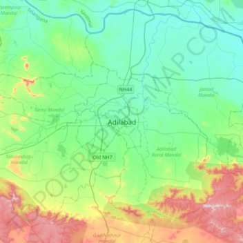
Nom : Carte topographique Adilabad, altitude, relief.
Altitude moyenne : 310 m
Altitude minimum : 196 m
Altitude maximum : 626 m
Adilabad has an average elevation of 264 metres. The district shares its boundaries with Nirmal districts of Telangana to the south, Komaram Bheem district on the east, with Nanded on the west and Yavatmal and Chandrapur districts of Maharashtra to the north.