
Carte topographique Queenstown
Carte interactive
Cliquez sur la carte pour afficher l’altitude.
À propos de cette carte
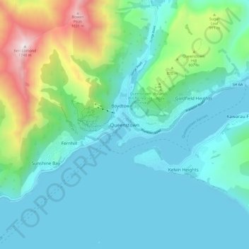
Nom : Carte topographique Queenstown, altitude, relief.
Altitude moyenne : 592 m
Altitude minimum : 303 m
Altitude maximum : 1 729 m
The town is at a relatively low altitude for a ski and snowboarding centre, at 310 metres (1,020 ft) above sea level at the lake shore, but is nestled among mountains, most notably the scenic attraction of The Remarkables, to the town's southeast. Below the lake lies the deep Kawarau Gorge, and there are nearby plains suitable for agriculture and viticulture. Queenstown lies close to the heart of the Central Otago wine region.
Autres cartes topographiques
Cliquez sur une carte pour visualiser sa topographie, son altitude et son relief.
Wānaka
New Zealand > Otago > Queenstown-Lakes District
Wānaka, Queenstown-Lakes District, Otago, 9305, New Zealand
Altitude moyenne : 381 m
Glenorchy
New Zealand > Otago > Queenstown-Lakes District
Glenorchy, Queenstown-Lakes District, Otago, 9372, New Zealand
Altitude moyenne : 384 m
Mount Selwyn
New Zealand > Otago > Queenstown-Lakes District
Mount Selwyn, Queenstown-Lakes District, Otago, New Zealand
Altitude moyenne : 853 m
Blanket Bay
New Zealand > Otago > Queenstown-Lakes District
Blanket Bay, Queenstown-Lakes District, Otago, 9372, New Zealand
Altitude moyenne : 337 m
Kingston
New Zealand > Otago > Queenstown-Lakes District
Kingston, Queenstown-Lakes District, Otago, New Zealand
Altitude moyenne : 507 m
Dalefield
New Zealand > Otago > Queenstown-Lakes District
Dalefield, Queenstown-Lakes District, Otago, New Zealand
Altitude moyenne : 475 m
Matukituki River
New Zealand > Otago > Queenstown-Lakes District
Matukituki River, Queenstown-Lakes District, Otago, New Zealand
Altitude moyenne : 337 m