
Carte topographique Leicester
Carte interactive
Cliquez sur la carte pour afficher l’altitude.
À propos de cette carte
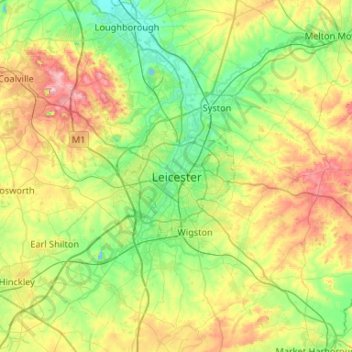
Nom : Carte topographique Leicester, altitude, relief.
Lieu : Leicester, Leicestershire, England, LE1 5YA, United Kingdom (52.47620 -1.29320 52.79620 -0.97320)
Altitude moyenne : 109 m
Altitude minimum : 33 m
Altitude maximum : 269 m
Autres cartes topographiques
Cliquez sur une carte pour visualiser sa topographie, son altitude et son relief.
Shepshed
United Kingdom > England > Leicestershire > Charnwood
Shepshed, Charnwood, Leicestershire, England, United Kingdom
Altitude moyenne : 111 m
Hemington
United Kingdom > England > Leicestershire > North West Leicestershire
Hemington, North West Leicestershire, Leicestershire, England, DE74 2TJ, United Kingdom
Altitude moyenne : 51 m
Mammoth Lake
United Kingdom > England > Leicestershire > Borough of Charnwood > Thurmaston
Mammoth Lake, Thurmaston, Borough of Charnwood, Leicestershire, England, United Kingdom
Altitude moyenne : 58 m
Harborough District
United Kingdom > England > Leicestershire
Harborough District, Leicestershire, England, United Kingdom
Altitude moyenne : 116 m
Braunstone Town
United Kingdom > England > Leicestershire > Braunstone Town
Braunstone Town, Blaby, Leicestershire, England, LE3 2SX, United Kingdom
Altitude moyenne : 78 m
Lutterworth
United Kingdom > England > Leicestershire > Harborough > Lutterworth
Lutterworth, Harborough, Leicestershire, East Midlands, England, United Kingdom
Altitude moyenne : 125 m
Ashby-de-la-Zouch
United Kingdom > England > Leicestershire > North West Leicestershire > Ashby-de-la-Zouch
Ashby-de-la-Zouch, North West Leicestershire, Leicestershire, East Midlands, England, United Kingdom
Altitude moyenne : 132 m
Desford
United Kingdom > England > Leicestershire > Hinckley and Bosworth
Desford, Hinckley and Bosworth, Leicestershire, England, United Kingdom
Altitude moyenne : 115 m
Leicestershire
United Kingdom > England > Leicestershire
Leicestershire, England, United Kingdom
Altitude moyenne : 98 m
Sileby
United Kingdom > England > Leicestershire > Charnwood
Sileby, Charnwood, Leicestershire, England, United Kingdom
Altitude moyenne : 69 m
Wanlip
United Kingdom > England > Leicestershire > Borough of Charnwood
Wanlip, Borough of Charnwood, Leicestershire, England, LE7 4PH, United Kingdom
Altitude moyenne : 61 m
Kibworth Harcourt
United Kingdom > England > Leicestershire > Harborough District
Kibworth Beauchamp, Kibworth Harcourt, Harborough District, Leicestershire, England, United Kingdom
Altitude moyenne : 113 m
Coalville
United Kingdom > England > Leicestershire > North West Leicestershire
Coalville, North West Leicestershire, Leicestershire, England, LE67 3DW, United Kingdom
Altitude moyenne : 149 m
Burrough on the Hill
United Kingdom > England > Leicestershire > Borough of Melton
Burrough on the Hill, Borough of Melton, Leicestershire, England, LE14 2JL, United Kingdom
Altitude moyenne : 153 m
Great Dalby
United Kingdom > England > Leicestershire > Borough of Melton
Great Dalby, Borough of Melton, Leicestershire, England, LE14 2EN, United Kingdom
Altitude moyenne : 121 m
Loughborough
United Kingdom > England > Leicestershire > Charnwood
Loughborough, Charnwood, Leicestershire, England, LE11 5BJ, United Kingdom
Altitude moyenne : 61 m