
Carte topographique Cambridge
Carte interactive
Cliquez sur la carte pour afficher l’altitude.
À propos de cette carte
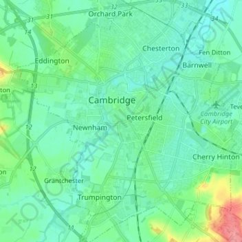
Nom : Carte topographique Cambridge, altitude, relief.
Altitude moyenne : 18 m
Altitude minimum : 2 m
Altitude maximum : 79 m
The city, like most of the UK, has a maritime climate highly influenced by the Gulf Stream. Located in the driest region of Britain, Cambridge's rainfall averages around 570 mm (22.44 in) per year, around half the national average, with some years occasionally falling into the semi-arid (under 500 mm (19.69 in) of rain per year) category. The last time this occurred was in 2011 with 380.4 mm (14.98 in) of rain at the Botanic Garden and 347.2 mm (13.67 in) at the NIAB site. Conversely, 2012 was the wettest year on record, with 812.7 mm (32.00 in) reported. Snowfall accumulations are usually small, in part because of Cambridge's low elevation, and low precipitation tendency during transitional snow events.
Autres cartes topographiques
Cliquez sur une carte pour visualiser sa topographie, son altitude et son relief.
West Pit
United Kingdom > England > Cambridge
West Pit, Lime Kiln Road, Cherry Hinton, Cambridge, Cambridgeshire, East of England, England, CB1 9NH, United Kingdom
Altitude moyenne : 26 m
Mansfield Court
United Kingdom > England > Cambridge
Mansfield Court, Cambridge, Cambridgeshire, East of England, England, CB4 1ES, United Kingdom
Altitude moyenne : 12 m
Quy Water
United Kingdom > England > Cambridge
Quy Water, Cambridge, Cambridgeshire, East of England, England, CB1 9BG, United Kingdom
Altitude moyenne : 13 m