
Carte topographique Lac Camatose
Carte interactive
Cliquez sur la carte pour afficher l’altitude.
À propos de cette carte
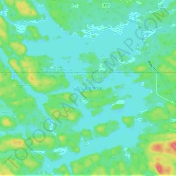
Nom : Carte topographique Lac Camatose, altitude, relief.
Altitude moyenne : 365 m
Altitude minimum : 349 m
Altitude maximum : 418 m
Autres cartes topographiques
Cliquez sur une carte pour visualiser sa topographie, son altitude et son relief.
Lac Doolittle
Canada > Québec > La Vallée-de-la-Gatineau > Lac-Pythonga
Lac Doolittle, Lac-Pythonga, La Vallée-de-la-Gatineau, Outaouais, Québec, Canada
Altitude moyenne : 379 m
Lac Rhéaume
Canada > Québec > La Vallée-de-la-Gatineau > Lac-Pythonga
Lac Rhéaume, Lac-Pythonga, La Vallée-de-la-Gatineau, Outaouais, Québec, Canada
Altitude moyenne : 296 m
Lac Jean Pere
Canada > Québec > La Vallée-de-la-Gatineau > Lac-Pythonga
Lac Jean Pere, Lac-Pythonga, La Vallée-de-la-Gatineau, Outaouais, Québec, Canada
Altitude moyenne : 386 m
Ruisseau Antostagan
Canada > Québec > La Vallée-de-la-Gatineau > Lac-Pythonga
Ruisseau Antostagan, Lac-Pythonga, La Vallée-de-la-Gatineau, Outaouais, Québec, Canada
Altitude moyenne : 395 m
Lac Camatose
Canada > Québec > La Vallée-de-la-Gatineau > Lac-Pythonga
Lac Camatose, Lac-Pythonga, La Vallée-de-la-Gatineau, Outaouais, Québec, Canada
Altitude moyenne : 362 m