
Carte topographique Bolton-by-Bowland
Carte interactive
Cliquez sur la carte pour afficher l’altitude.
À propos de cette carte
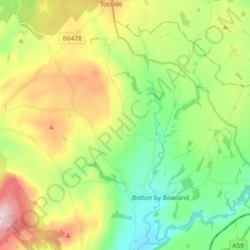
Nom : Carte topographique Bolton-by-Bowland, altitude, relief.
Altitude moyenne : 193 m
Altitude minimum : 72 m
Altitude maximum : 394 m
Autres cartes topographiques
Cliquez sur une carte pour visualiser sa topographie, son altitude et son relief.
Clitheroe
United Kingdom > England > Ribble Valley > Clitheroe
Clitheroe, Lancashire, North West England, England, BB7 2BT, United Kingdom
Altitude moyenne : 125 m
Bolton by Bowland
United Kingdom > England > Ribble Valley > Bolton by Bowland
Bolton by Bowland, Ribble Valley, Lancashire, North West England, England, BB7 4NQ, United Kingdom
Altitude moyenne : 133 m
Billington and Langho
United Kingdom > England > Ribble Valley
Billington and Langho, Ribble Valley, Lancashire, North West England, England, United Kingdom
Altitude moyenne : 100 m
Simonstone
United Kingdom > England > Ribble Valley > Simonstone
Simonstone, Ribble Valley, Lancashire, North West England, England, United Kingdom
Altitude moyenne : 135 m
Brennand River
United Kingdom > England > Ribble Valley
Brennand River, Ribble Valley, Lancashire, North West England, England, BB7 3BL, United Kingdom
Altitude moyenne : 326 m
Whitendale River
United Kingdom > England > Ribble Valley
Whitendale River, Ribble Valley, Lancashire, North West England, England, BB7 3BL, United Kingdom
Altitude moyenne : 356 m
Aighton, Bailey and Chaigley
United Kingdom > England > Ribble Valley
Aighton, Bailey and Chaigley, Ribble Valley, Lancashire, North West England, England, United Kingdom
Altitude moyenne : 122 m
River Dunsop
United Kingdom > England > Ribble Valley
River Dunsop, Ribble Valley, Lancashire, North West England, England, BB7 3BD, United Kingdom
Altitude moyenne : 244 m