
Carte topographique Lake Powell
Carte interactive
Cliquez sur la carte pour afficher l’altitude.
À propos de cette carte
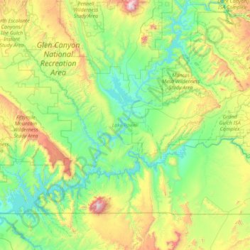
Nom : Carte topographique Lake Powell, altitude, relief.
Lieu : Lake Powell, San Juan County, Utah, United States (36.84441 -111.56748 37.90938 -110.28672)
Altitude moyenne : 1 555 m
Altitude minimum : 1 103 m
Altitude maximum : 3 236 m
Concrete placement started around the clock on June 17, 1960. The last bucket of concrete was poured on September 13, 1963. Over 5 million cubic yards (4,000,000 m³) of concrete make up Glen Canyon Dam. The dam is 710 feet (216 m) high and the surface elevation of the water at full-pool is approximately 3700 feet (1100 m). Construction of the dam cost $155 million, and 18 people died in the process. From 1970 to 1980, turbines and generators were installed for hydroelectricity. On September 22, 1966, Glen Canyon Dam was dedicated by Lady Bird Johnson.
Autres cartes topographiques
Cliquez sur une carte pour visualiser sa topographie, son altitude et son relief.
Upheaval Dome
United States > Utah > San Juan County
Upheaval Dome, San Juan County, Utah, United States
Altitude moyenne : 1 627 m
Halchita
United States > Utah > San Juan County
Halchita, San Juan County, Utah, United States
Altitude moyenne : 1 398 m
Colorado Plateau
United States > Utah > San Juan County
Colorado Plateau, San Juan County, Utah, United States
Altitude moyenne : 1 512 m
Aneth
United States > Utah > San Juan County
Aneth, Shiprock Agency, San Juan County, Utah, United States
Altitude moyenne : 1 422 m
Monticello
United States > Utah > San Juan County
Monticello, San Juan County, Utah, United States
Altitude moyenne : 2 145 m
La Sal
United States > Utah > San Juan County
La Sal, San Juan County, Utah, 84530, United States
Altitude moyenne : 2 098 m
Bluff
United States > Utah > San Juan County
Bluff, San Juan County, Utah, 84512, United States
Altitude moyenne : 1 424 m