
Carte topographique Lake Roosevelt
Carte interactive
Cliquez sur la carte pour afficher l’altitude.
À propos de cette carte
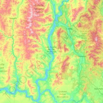
Nom : Carte topographique Lake Roosevelt, altitude, relief.
Lieu : Lake Roosevelt, Stevens County, Washington, United States (47.81285 -118.99057 48.82592 -117.92095)
Altitude moyenne : 903 m
Altitude minimum : 381 m
Altitude maximum : 2 166 m
Autres cartes topographiques
Cliquez sur une carte pour visualiser sa topographie, son altitude et son relief.
Spokane Indian Reservation
United States > Washington > Stevens County
Spokane Indian Reservation, Stevens County, Washington, 99040, United States
Altitude moyenne : 713 m
Ford
United States > Washington > Stevens County
Ford, Stevens County, Washington, United States
Altitude moyenne : 577 m
Wellpinit
United States > Washington > Stevens County
Wellpinit, Stevens County, Washington, 99040, United States
Altitude moyenne : 762 m
Loon Lake
United States > Washington > Stevens County
Loon Lake, Stevens County, Washington, 99148, United States
Altitude moyenne : 751 m
Rice
United States > Washington > Stevens County
Rice, Stevens County, Washington, 99167, United States
Altitude moyenne : 536 m
Camas
United States > Washington > Stevens County
Camas, Stevens County, Washington, United States
Altitude moyenne : 706 m
Springdale
United States > Washington > Stevens County
Springdale, Stevens County, Washington, United States
Altitude moyenne : 656 m
Kettle Falls
United States > Washington > Stevens County
Kettle Falls, Stevens County, Washington, 99141, United States
Altitude moyenne : 509 m
Evans
United States > Washington > Stevens County
Evans, Stevens County, Washington, 99126, United States
Altitude moyenne : 487 m
Chewelah
United States > Washington > Stevens County
Chewelah, Stevens County, Washington, United States
Altitude moyenne : 590 m
Boundary
United States > Washington > Stevens County > Boundary
Boundary, Stevens County, Washington, United States
Altitude moyenne : 611 m
Colville
United States > Washington > Stevens County
Colville, Stevens County, Washington, United States
Altitude moyenne : 559 m
Chewelah
United States > Washington > Stevens County > Chewelah > Chewelah
Chewelah, Stevens County, Washington, United States
Altitude moyenne : 611 m
Northport
United States > Washington > Stevens County > Northport
Northport, Stevens County, Washington, United States
Altitude moyenne : 502 m
Colville
United States > Washington > Stevens County > Colville > Colville
Colville, Stevens County, Washington, United States
Altitude moyenne : 602 m