
Carte topographique Fiordland National Park
Carte interactive
Cliquez sur la carte pour afficher l’altitude.
À propos de cette carte
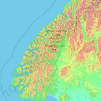
Nom : Carte topographique Fiordland National Park, altitude, relief.
Lieu : Fiordland National Park, New Zealand (-46.25124 166.42555 -44.33187 168.23983)
Altitude moyenne : 417 m
Altitude minimum : 0 m
Altitude maximum : 2 819 m
Several large lakes lie wholly or partly within the park's boundaries, notably Lake Te Anau and Lake Manapouri, both on the western boundary of the national park, as well as the southern lakes Lake Monowai, Lake Hauroko, and Lake Poteriteri. All of these lakes exhibit the topography typical of glacier-carved valleys, with Lake Te Anau and Lake Manapouri in particular having several arms similar in look to the fiords on the west coast of the park.
Autres cartes topographiques
Cliquez sur une carte pour visualiser sa topographie, son altitude et son relief.
Dragons Teeth
New Zealand > Tasman > Tasman District
Dragons Teeth, Tasman District, Tasman, New Zealand
Altitude moyenne : 1 214 m
Sutherland Falls
New Zealand > Southland > Southland District > Fiordland Community
Sutherland Falls, Fiordland Community, Southland District, Southland, New Zealand
Altitude moyenne : 1 006 m
Ohinepaka Bay
New Zealand > Canterbury > Christchurch City > Banks Peninsula Community > Wainui
Ohinepaka Bay, Wainui, Banks Peninsula Community, Christchurch City, Canterbury, 7582, New Zealand
Altitude moyenne : 94 m
Great Barrier Island
Great Barrier Island, Auckland, 0991, New Zealand
Altitude moyenne : 31 m
Pitt Island (Rangiauria)
Pitt Island (Rangiauria), Chatham Islands, New Zealand
Altitude moyenne : 10 m
Rakiura Rocks
New Zealand > Marlborough > Marlborough District
Rakiura Rocks, Marlborough District, Marlborough, New Zealand
Altitude moyenne : 10 m
Pōkeno
New Zealand > Waikato > Waikato District
Pōkeno, Waikato District, Waikato, 2472, New Zealand
Altitude moyenne : 66 m
Woodend Beach
New Zealand > Canterbury > Waimakariri District
Woodend Beach, Waimakariri District, Canterbury, 7612, New Zealand
Altitude moyenne : 3 m
Cascade Kauri Picture Frame
New Zealand > Auckland > Waitakere Ranges
Cascade Kauri Picture Frame, Falls Road, Waitākere Ranges, Auckland, 0816, New Zealand
Altitude moyenne : 141 m
Pyramids
New Zealand > Otago > Dunedin City
Pyramids, Dunedin City, Otago, New Zealand
Altitude moyenne : 52 m
Gisborne
New Zealand > Gisborne > Gisborne District
Gisborne, Gisborne District, Gisborne, 4010, New Zealand
Altitude moyenne : 70 m
Mount Livingstone
New Zealand > Canterbury > Mackenzie District
Mount Livingstone, Mackenzie District, Canterbury, New Zealand
Altitude moyenne : 1 945 m
Selwyn District
Selwyn District, Canterbury, New Zealand
Altitude moyenne : 679 m
Punakaiki
New Zealand > West Coast > Buller District
Punakaiki, Buller District, West Coast, 7873, New Zealand
Altitude moyenne : 70 m
Days Bay
New Zealand > Wellington > Lower Hutt
Days Bay, Lower Hutt, Wellington, 5013, New Zealand
Altitude moyenne : 74 m
Upper Hutt
New Zealand > Wellington > Upper Hutt City
Upper Hutt, Upper Hutt City, Wellington, 5218, New Zealand
Altitude moyenne : 271 m
Snow Bowl
New Zealand > Taranaki > Stratford District
Snow Bowl, Stratford District, Taranaki, New Zealand
Altitude moyenne : 1 467 m
Central Otago
New Zealand > Otago > Central Otago District > Vincent Community
Central Otago, Vincent Community, Central Otago District, Otago, 9035, New Zealand
Altitude moyenne : 935 m
Hahei Beach
New Zealand > Waikato > Thames-Coromandel District > Hahei
Hahei Beach, Hahei, Thames-Coromandel District, Waikato, New Zealand
Altitude moyenne : 29 m
Tikorangi
New Zealand > Bay of Plenty > Whakatāne District
Tikorangi, Whakatāne District, Bay of Plenty, New Zealand
Altitude moyenne : 484 m
Lake Panorama
New Zealand > Auckland > Henderson-Massey
Lake Panorama, Western Heights, Henderson-Massey, Auckland, New Zealand
Altitude moyenne : 52 m
Mana Island
New Zealand > Wellington > Porirua City > Porirua
Mana Island, Porirua, Porirua City, Wellington, New Zealand
Altitude moyenne : 16 m
Putāruru
New Zealand > Waikato > South Waikato District
Putāruru, South Waikato District, Waikato, 3411, New Zealand
Altitude moyenne : 166 m
Kaimai Range
New Zealand > Bay of Plenty > Western Bay of Plenty District
Kaimai Range, Western Bay of Plenty District, Bay of Plenty, New Zealand
Altitude moyenne : 595 m
Waiari Reserve
New Zealand > Auckland > Papakura
Waiari Reserve, Conifer Grove, Papakura, Auckland, New Zealand
Altitude moyenne : 12 m
Ōakura
New Zealand > Taranaki > New Plymouth District
Ōakura, New Plymouth District, Taranaki, 4314, New Zealand
Altitude moyenne : 74 m
Shalamar Reserve
New Zealand > Canterbury > Christchurch City > Christchurch
Shalamar Reserve, Cashmere, Christchurch, Christchurch City, Canterbury, New Zealand
Altitude moyenne : 48 m
Remus
New Zealand > Canterbury > Selwyn District
Remus, Selwyn District, Canterbury, New Zealand
Altitude moyenne : 620 m
Whitianga
New Zealand > Bay of Plenty > Ōpōtiki District
Whitianga, Ōpōtiki District, Bay of Plenty, 3162, New Zealand
Altitude moyenne : 42 m
Cape Kidnappers / Te Kauwae-a-Māui
New Zealand > Hawke's Bay > Hastings District
Cape Kidnappers / Te Kauwae-a-Māui, Hastings District, Hawke's Bay, New Zealand
Altitude moyenne : 16 m
Wilson's Beach
New Zealand > Auckland > Ōrākei
Wilson's Beach, Ōrākei, Auckland, New Zealand
Altitude moyenne : 21 m
Douglas Pass
New Zealand > West Coast > Westland District
Douglas Pass, Westland District, West Coast, New Zealand
Altitude moyenne : 1 603 m
Little River
Little River, Canterbury, New Zealand, Whale Island
Altitude moyenne : 9 m
Coastal-Burwood Community
New Zealand > Canterbury > Christchurch City
Coastal-Burwood Community, Christchurch City, Canterbury, New Zealand
Altitude moyenne : 6 m
Bridal Veil Falls
New Zealand > Waikato > Rotorua Lakes District
Bridal Veil Falls, Rotorua Lakes District, Waikato, New Zealand
Altitude moyenne : 353 m
Lake Windermere
New Zealand > West Coast > Westland District
Lake Windermere, Westland District, West Coast, New Zealand
Altitude moyenne : 4 m
Round Knob
New Zealand > Manawatu-Whanganui > Tararua District
Round Knob, Tararua District, Manawatū-Whanganui, New Zealand
Altitude moyenne : 239 m
Zig Zag
New Zealand > Canterbury > Christchurch City > Banks Peninsula Community
Zig Zag, Banks Peninsula Community, Christchurch City, Canterbury, New Zealand
Altitude moyenne : 136 m