
Carte topographique Istor-o-Nal
Carte interactive
Cliquez sur la carte pour afficher l’altitude.
À propos de cette carte
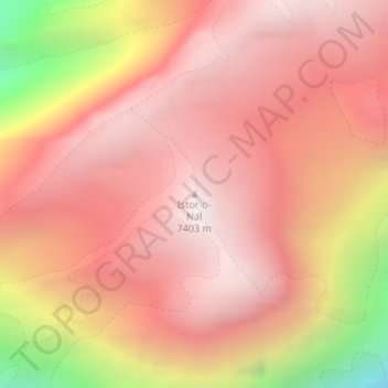
Nom : Carte topographique Istor-o-Nal, altitude, relief.
Lieu : Istor-o-Nal, Chitrāl District, Khyber Pakhtunkhwa, Pakistan (36.37724 71.89746 36.37734 71.89756)
Altitude moyenne : 6 853 m
Altitude minimum : 5 670 m
Altitude maximum : 7 382 m
Autres cartes topographiques
Cliquez sur une carte pour visualiser sa topographie, son altitude et son relief.
District de Chitrâl
District de Chitrâl, Division de Malakand, Khyber Pakhtunkhwa, Pakistan
Altitude moyenne : 3 729 m
Peshawar
Pakistan > Khyber Pakhtunkhwa > Peshawar
Peshawar, Peshāwar District, Khyber Pakhtunkhwa, Pakistan
Altitude moyenne : 359 m
Khyber Pakhtunkhwa
Khyber Pakhtunkhwa, Pakistan
Altitude moyenne : 2 135 m
Nowshak
Nowshak, Chitrāl District, Khyber Pakhtunkhwa, Pakistan
Altitude moyenne : 6 863 m
Tirich Mir
Tirich Mir, Chitrāl District, Khyber Pakhtunkhwa, Pakistan
Altitude moyenne : 6 886 m