
Carte topographique Pemalang
Carte interactive
Cliquez sur la carte pour afficher l’altitude.
À propos de cette carte
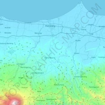
Nom : Carte topographique Pemalang, altitude, relief.
Lieu : Pemalang, Java central, 52361, Indonésie (-7.24889 109.18559 -6.77227 109.59920)
Altitude moyenne : 294 m
Altitude minimum : -1 m
Altitude maximum : 3 408 m
Autres cartes topographiques
Cliquez sur une carte pour visualiser sa topographie, son altitude et son relief.
Wringinputih
Indonésie > Java central > Magelang
Wringinputih, Magelang, Java central, 56553, Indonésie
Altitude moyenne : 252 m
Purwokerto
Indonésie > Java central > Purwokerto
Purwokerto, Banyumas, Java central, 53116, Indonésie
Altitude moyenne : 277 m
Karanganyar
Indonésie > Java central > Semarang
Karanganyar, Tugu, Semarang, Java central, Indonésie
Altitude moyenne : 7 m
Puncak Trianggulasi
Indonésie > Java central > Jrakah
Puncak Trianggulasi, Jrakah, Boyolali, Java central, Indonésie
Altitude moyenne : 2 696 m
Gunung Lawu
Indonésie > Java central > Ngancar
Gunung Lawu, Gunung Lawu Track, Ngancar, Magetan, Java central, Indonésie
Altitude moyenne : 2 881 m
Wonosobo
Indonésie > Java central > Wonosobo
Wonosobo, Java central, 56311, Indonésie
Altitude moyenne : 776 m
Telomoyo
Indonésie > Java central > Salatiga
Telomoyo, Salatiga, Java central, 56194, Indonésie
Altitude moyenne : 1 386 m
Boyolali
Indonésie > Java central > Boyolali
Boyolali, Java central, 57311, Indonésie
Altitude moyenne : 403 m