
Carte topographique Lake Como
Carte interactive
Cliquez sur la carte pour afficher l’altitude.
À propos de cette carte
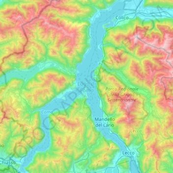
Nom : Carte topographique Lake Como, altitude, relief.
Lieu : Lake Como, Como, Lombardy, 23829, Italy (45.81316 9.06673 46.17036 9.38897)
Altitude moyenne : 885 m
Altitude minimum : 188 m
Altitude maximum : 2 593 m
Lake Como weather is humid subtropical (Cfa in the Köppen climate classification). In the winter, the lake helps to maintain a higher temperature in the surrounding region. Average daily temperatures range from about 3.7 °C (39 °F) in January to 23.4 °C (74 °F) in July, according to historical weather data from Como. Water temperatures can reach an average of 24 °C (75 °F) during the month of July. Snowfall is erratic and primarily affects the higher elevations. Rainfall is heaviest in May and lowest during the winter months.
Autres cartes topographiques
Cliquez sur une carte pour visualiser sa topographie, son altitude et son relief.
Aureggio
Italy > Lombardy > Como > San Giovanni
Aureggio, San Giovanni, Bellagio, Como, Lombardy, 22021, Italy
Altitude moyenne : 249 m