
Carte topographique Puerto de la Cruz
Carte interactive
Cliquez sur la carte pour afficher l’altitude.
À propos de cette carte
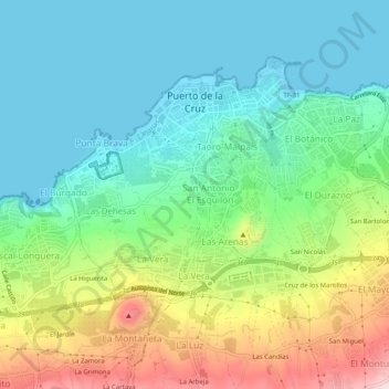
Nom : Carte topographique Puerto de la Cruz, altitude, relief.
Altitude moyenne : 129 m
Altitude minimum : 0 m
Altitude maximum : 423 m
Autres cartes topographiques
Cliquez sur une carte pour visualiser sa topographie, son altitude et son relief.
Costa Brava
Suivant sa diversité géographique, cette zone présente de nombreux climats et microclimats qui dépendent de l’altitude et de la proximité de la mer. En général, on peut dire que le climat est tempéré et doux, de type méditerranéen, caractérisé par des étés secs et chauds et par des hivers modérés.
Altitude moyenne : 247 m
Pyrénées
Les Pyrénées sont une chaîne montagneuse du sud-ouest de l'Europe. Elles s'étendent en longueur selon une direction est-ouest sur une distance approximative de 430 kilomètres depuis la mer Méditerranée (Cap de Creus) jusqu'au golfe de Gascogne (Cap Higuer). Barrière géographique résultant de la…
Altitude moyenne : 491 m
Pique d'Estats
Espagne > Catalogne > Pallars-Supérieur > Alins
Avec 3 143 mètres d'altitude, c'est le plus haut sommet du massif du Montcalm.
Altitude moyenne : 2 744 m
Font d'en Joanic
Espagne > Catalogne > Plaine de l'Estagne > Palol de Revardit
Altitude moyenne : 136 m
Puig Major
Espagne > Îles Baléares > Serra de Tramuntana > Escorca
Le Puig Major est le sommet le plus élevé de l'île de Majorque et des îles Baléares avec 1 436 mètres d'altitude. La montagne culmine sur la municipalité d'Escorca et s'étend également sur celle de Fornalutx. Son éperon sud s'appelle le Penyal des Migdia (es).
Altitude moyenne : 949 m
Pampelune
Espagne > Navarre > Iruñerria / Comarca de Pamplona
Elle se situe à 440 mètres d'altitude. Elle a une population de 204 000 habitants et est la ville principale de la Cuenca de Pampelune, aire urbaine de plus de 350 000 habitants. Elle est située dans la zone linguistique mixte de la province.
Altitude moyenne : 611 m
Los Jopos
Espagne > Région de Murcie > Haut-Guadalentin > Lorca > Los Abades y las Norias
Altitude moyenne : 335 m
Rodellar
Espagne > Aragon > Somontano de Barbastro > Bierge
Rodellar, à une altitude de 761 m, est situé à 59 km de Huesca, la capitale de la province.
Altitude moyenne : 937 m
Costera de la Llacuna
Espagne > Communauté Valencienne > Vilallonga / Villalonga
Altitude moyenne : 331 m
Tuc de Maubèrme
Espagne > Catalogne > Val-d'Aran
Le pic de Maubermé (tuc de Maubèrme en catalan) est un sommet frontalier des Pyrénées culminant de 2 880 à 2 882 m d'altitude entre l'Espagne et la France. Côté français, il se situe dans le département de l'Ariège en région Occitanie. Côté espagnol, il se situe dans la province de Lérida en Catalogne.
Altitude moyenne : 2 388 m
Cascada de las Ollerías / Ollerias ur-jauzia
Espagne > Pays basque autonome > Montagne Alavaise > Peñacerrada-Urizaharra
Altitude moyenne : 806 m