
Carte topographique Dharamsala
Carte interactive
Cliquez sur la carte pour afficher l’altitude.
Dharamsala
La ville s'étend sur 27,6 km2 à une altitude moyenne de 1 457 mètres. L'agglomération se divise en deux parties.
À propos de cette carte
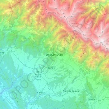
Nom : Carte topographique Dharamsala, altitude, relief.
Altitude moyenne : 1 781 m
Altitude minimum : 485 m
Altitude maximum : 4 909 m