
Carte topographique Tbilissi
Carte interactive
Cliquez sur la carte pour afficher l’altitude.
Tbilissi
La ville de Tbilissi, d'une superficie de 726 km2, s'étale à des altitudes comprises entre 380 m et 770 m au-dessus du niveau de la mer. Au nord, la ville est limitée par la cordillère de Sagouramo, à l'est et au sud-est par la plaine de Iori, et à l'ouest, son expansion est empêchée par la cordillère de Trialéti, de relief plutôt accidenté.
À propos de cette carte
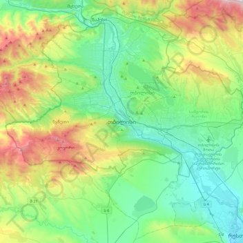
Nom : Carte topographique Tbilissi, altitude, relief.
Lieu : Tbilissi, 0136, Géorgie (41.53346 44.64145 41.85346 44.96145)
Altitude moyenne : 713 m
Altitude minimum : 319 m
Altitude maximum : 1 730 m
Autres cartes topographiques
Cliquez sur une carte pour visualiser sa topographie, son altitude et son relief.