Carte topographique Sirohi
Carte interactive
Cliquez sur la carte pour afficher l’altitude.
À propos de cette carte
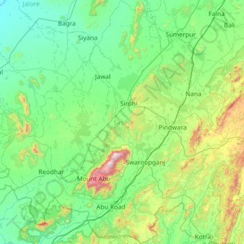
Nom : Carte topographique Sirohi, altitude, relief.
Lieu : Sirohi, Rajasthan, India (24.33736 72.24644 25.28431 73.17251)
Altitude moyenne : 351 m
Altitude minimum : 109 m
Altitude maximum : 1 678 m
Sirohi District is broken up by hills and rocky ranges. The granite massif of Mount Abu divides the district into two portions, running from north-east to south-west. The south and south-east part of the district, which lies between Mount Abu and the main spine of the Aravallis, is mountainous and rugged, and is drained by the West Banas River. Abu Road, a station on the main Delhi-Ahmedabad rail line, lies in the valley of the West Banas. Dry deciduous forest is common in this part of the district, and the higher elevations of Mount Abu are covered in conifer forests. Abu Road is the biggest city and the main financial hub of Sirohi District. Sirohi district has the fewest villages in Rajasthan.
Autres cartes topographiques
Cliquez sur une carte pour visualiser sa topographie, son altitude et son relief.
Jaipur
India > Rajasthan > Jaipur Tehsil
Jaipur, Jaipur Municipal Corporation, Jaipur Tehsil, Jaipur, Rajasthan, 302001, India
Altitude moyenne : 408 m
Kerla
India > Rajasthan > Pali Tehsil
Kerla, Pali Tehsil, Pali District, Rajasthan, India
Altitude moyenne : 199 m
Dei
India > Rajasthan > Nainwa Tehsil
Dei, Nainwa Tehsil, Bundi District, Rajasthan, India
Altitude moyenne : 262 m
Talwara
India > Rajasthan > Banswara Tehsil
Talwara, Banswara Tehsil, Banswara District, Rajasthan, 327025, India
Altitude moyenne : 196 m
Majarakath
India > Rajasthan > Neemrana Tehsil > Majarakath
Majarakath, Neemrana Tehsil, Alwar District, Rajasthan, 301706, India
Altitude moyenne : 322 m
Banora
India > Rajasthan > Salumbar Tehsil > Banora
Banora, Salumbar Tehsil, Udaipur, Rajasthan, 313027, India
Altitude moyenne : 267 m
Burwa
India > Rajasthan > Bagidora Tehsil > Burwa
Burwa, Bagidora Tehsil, Banswara, Rajasthan, 327604, India
Altitude moyenne : 264 m
Kanwal
India > Rajasthan > Degana Tehsil > Kanwal
Kanwal, Degana Tehsil, Nagaur, Rajasthan, India
Altitude moyenne : 356 m
Bhanda
India > Rajasthan > Nimba Ka Talab > Bhanda
Bhanda, Nimba Ka Talab, Osian Tehsil, Jodhpur, Rajasthan, India
Altitude moyenne : 297 m
Aravalli Range
Aravalli Range, Abu Road Tehsil, Sirohi, Rajasthan, 307501, India
Altitude moyenne : 1 339 m
Guru Shikhar, Abu
Guru Shikhar, Abu, Abu Road Tehsil, Sirohi, Rajasthan, 307501, India
Altitude moyenne : 1 366 m