Géolocaliser

Carte topographique Ruse

Carte interactive

Cliquez sur la carte pour afficher l’altitude.

À propos de cette carte
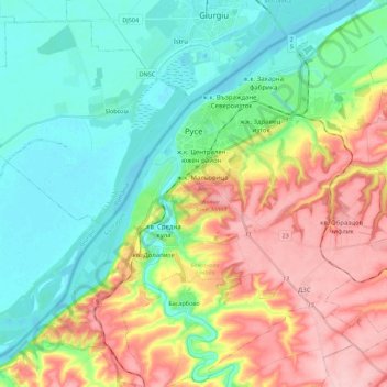
Nom : Carte topographique Ruse, altitude, relief.

Lieu : Ruse, Bulgaria (43.74200 25.86364 43.90187 26.08241)

Altitude moyenne : 72 m

Altitude minimum : 14 m

Altitude maximum : 171 m

Ruse is on the right bank of the river Danube, which is the high bank, having two underwater terraces and three river terraces at 15 to 22 m (49.21–72.18 ft), 30 to 66 m (98.43–216.54 ft), and 54 to 65 m (177.17–213.25 ft). The average altitude is 45.5 m (149.28 ft) AMSL. The urban area is an approximately 11-km ellipse running along the river. The city extends from the land-connected Matey (Матей) island and the mouth of Rusenski Lom on the west to Srabcheto (Сръбчето) hill on the east. During the 20th century, the west end of the city was significantly modified by moving the mouth of Rusenski Lom to the west, as well as by moving the bank itself with its fairway considerably to the north. Sarabair (саръбаир, from Turkish Sarıbayır meaning "Yellow Slope") hill is to the south of the city and is 159 m (521.65 ft) high. The Rousse TV Tower is built there on the remains of Leventtabia, a former Turkish fortification.

Wikipedia (CC-BY-SA 3.0)

Autres cartes topographiques

Cliquez sur une carte pour visualiser sa topographie, son altitude et son relief.

Marten

Bulgaria > Ruse

Marten, Ruse, 7058, Bulgaria

Altitude moyenne : 31 m

Sandrovo

Bulgaria > Ruse

Sandrovo, Ruse, 7059, Bulgaria

Altitude moyenne : 25 m

Ruse

Bulgaria > Ruse

Ruse, Bulgaria

Altitude moyenne : 62 m

Bistrentsi

Bulgaria > Ruse

Bistrentsi, Biala, Ruse, Bulgaria

Altitude moyenne : 263 m

Byala

Bulgaria > Ruse

Byala, Biala, Ruse, 7100, Bulgaria

Altitude moyenne : 151 m